
“These are Sinister and supernatural figures, gods from the underworld perhaps, who hover in space, or dance, or stand solidly planted on two feet carrying weapons- a club or sword. Most are faceless but some stare back at you with large, hollow, quiet eyes. Demonic shapes, they might have meant protection and benevolence to their creators and a threat to strangers: Beware, traveler. You are approaching the land of the horned gods….”
Edward Abbey, Desert Solitaire
Dropping In
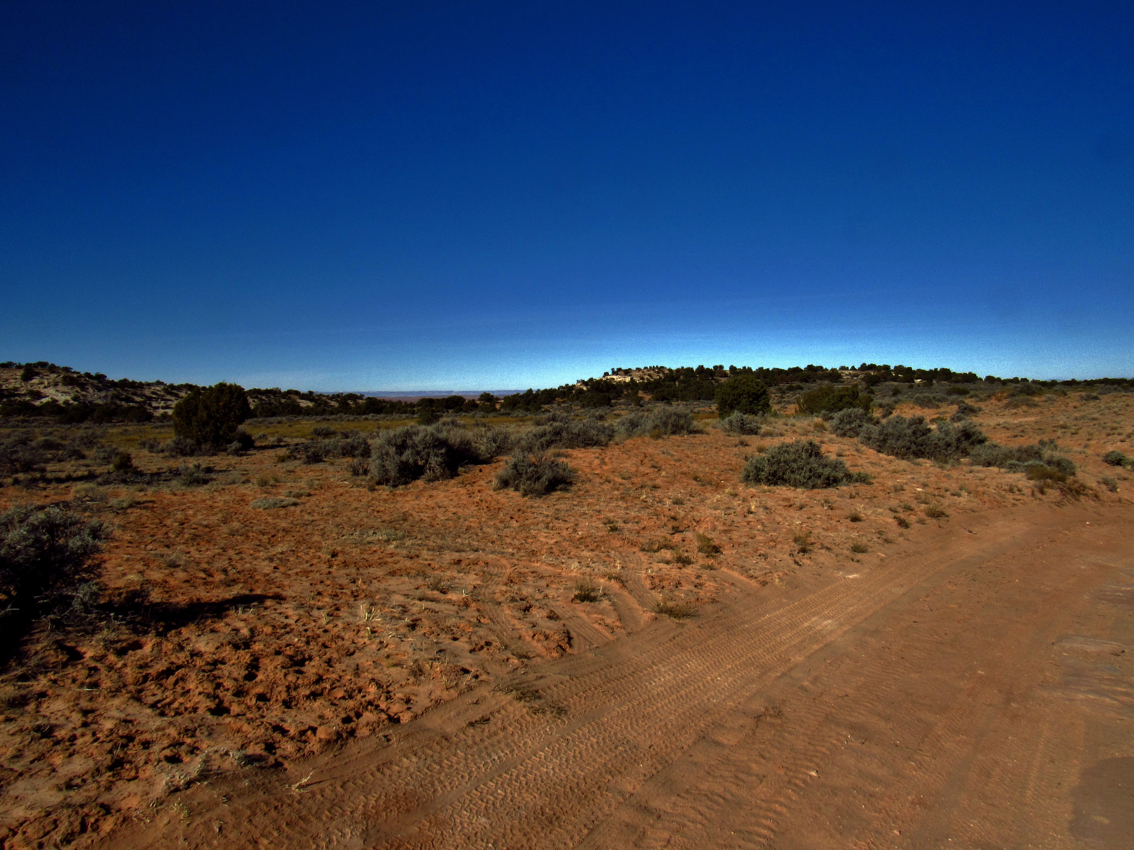
Horseshoe Canyon Entrance
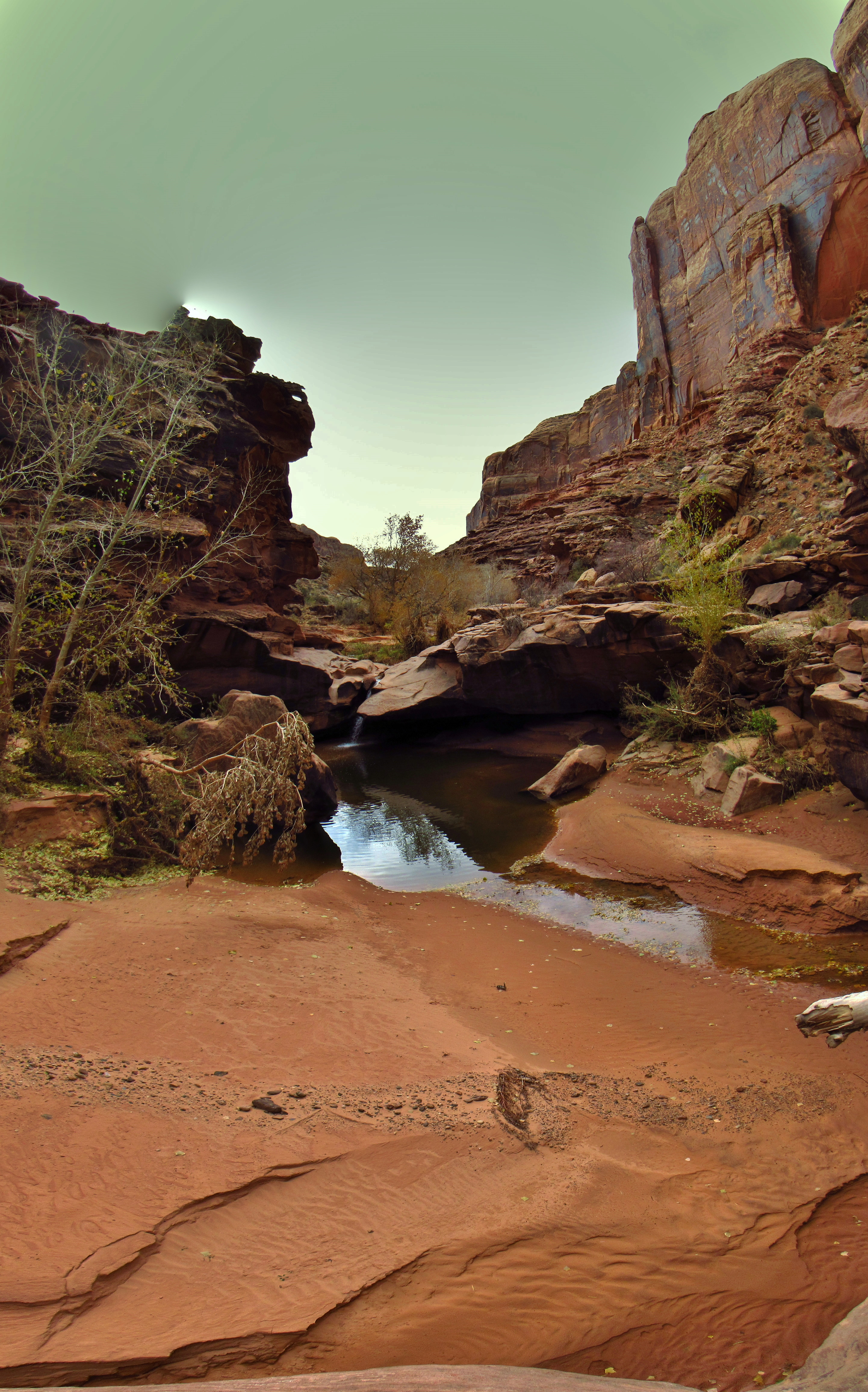
Less than a mile from the tippy top of Horseshoe Canyon is an overlook on a northward facing point; bubbly, bulbous globs of Navajo Sandstone with foot-wide washes between, prickly dead-or-alive pinyons or junipers and elder patches of biological soil crust growing in them, and the Wingate cliffs dropping down from 3 sides, deep enough that a thrown stone might not be heard for 3 seconds before it hits the wash below, and grand enough that the last echo from the surrounding walls would sound 8 or 9 seconds later. The very end of the point is sheer, except for a 30 foot wide, round-topped boulder leaning against it and its 60°, roughly 30 foot tall face that leads to the sand bank below. There’s a thin crack between the boulder and the point itself, but it’d be a difficult off-width and traversy down-climb, especially with a pack that surely weighs more than 70 pounds and maybe as much as 85. But there’s another route down a 9 foot long straight crack on the face of the boulder, to a 2 foot wide and 5 foot long ledge, then step off onto easy scramblable smaller boulders to the sand. Except that the other side of this little 2×5 ledge has like 100+ feet of exposure. Easy move physically, bold move mentally. But I’ve got the line for my tarp, maybe 90 feet of it in 6 or 12 foot strands. So with one end of one strand tied to the backpack handle, all the strands tied together to make one continuous piece, and overhand loop knots on each strand to use as handles to line the pack down the face, I straddled a juniper trunk and kicked the backpack over the ledge. It stalled for a second and a quick jiggle of the line unstuck it and the line went taut. But only for an instant. One of the knots in the thin line pulled out and my pack fell let’s say 27 feet into sand. All my food and gear for the next 2 weeks is in that backpack down at the bottom of the cliff, so now I’m committed to that little 2 foot ledge. I kept my camera around my neck and a bottle caribenered to it, so I’d climb down with them, but the trekking poles I softly javilined into the sand below. The crack was a 5.5 or 5.6 at best, basically one hand jam to lower down to a small but reliable foot hold that put your face at the edge of the boulder, a small imperfection in the otherwise smooth cliff face that stretched on under the ledge forever. Here is the crux of the simple downclimb- 3 feet of smooth featureless rock between that small but reliable foothold and the 2×5 ledge. A quick jump as I let go of the hand jam. Without the exposure, it’s a mindlessly easy hop down onto solid ground. But I acknowledged and accepted the risk of a fall that probably wouldn’t kill me upon impact (which is arguably worse than one that would when you consider how far you are in space and time from rescue, even with an oh-shit-button) and I took one measured, deep breath. Piece of cake. Scrambled down to my pack, collected the nalgenes that had shot out of the mesh side pockets and down the sand bank, then had to take everything out of my pack to pull the aluminum frame stay out and bend it back into shape over my knee. The impact torqued it a bit, though not seriously. Repack, land ski down the sand to a couple one footer ledges and into the wash. I’m relieved. Horseshoe Canyon is not a place people often enter from the top, and this point only came to my attention as a plausible entry after studying the slope angle shading setting on Caltopo, and a ground level perspective on Google Earth that suggested that this was the best option within a few more miles of the top. None of the old-heads in Moab that I talked to had entered in from the top before, and didn’t readily know anyone that had either. It was a gamble, a guess. But a reasonable one with plans B, C, and D to back it up. 30+ miles to the Green River, 50+ after that on this loop, and 2 more 100+ mile loops after that. This is the Maze Trip. The one I’d started thinking about 2 years ago. And Horseshoe Canyon is the way it all begins.

Top of Horseshoe Canyon. To the left of dead center of this photo is a juniper growing in the crack between the boulder and the point. On the shadowed side of that is the crack I climbed down, and the sunlit face of the big block is where I tried to line down my pack
Backpack on Wheels
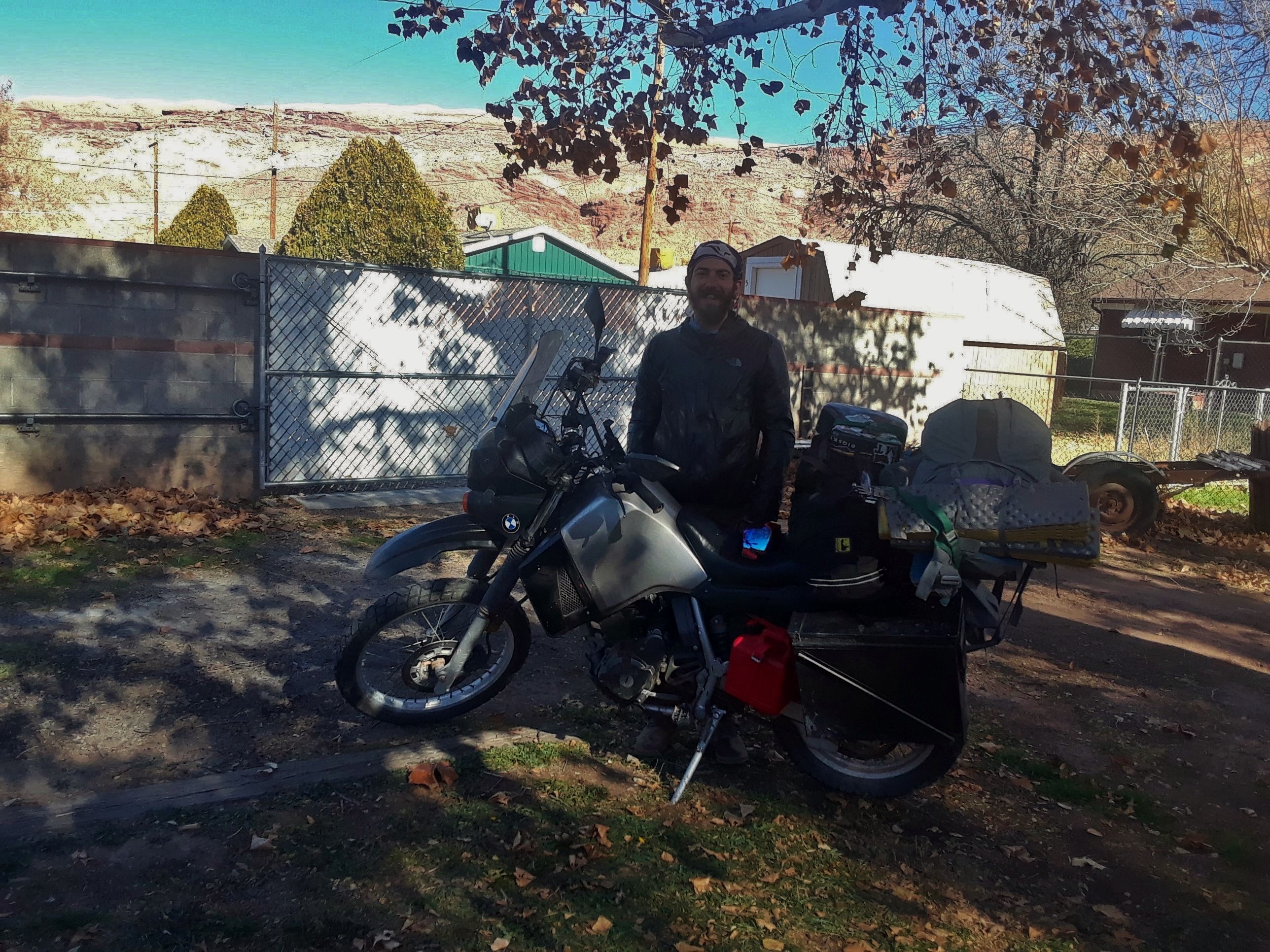
Loaded KLR
I got a motorcycle this summer. My first one. A Kawasaki KLR 650. Big bike for a less than big dude. Some rocket boxes, black, on either side of the back tire, a Wolfman saddle bag behind me on a wooden rack with angle aluminum edging U-bolted to the frame. Twin Corral Flats is about 88 miles away from Moab, 45 miles of that on the Lower San Rafael Rd (the Hans Flat Road as the locals might call it) which leads to the Hans Flat Ranger Station at the entrance to the Maze District of Canyonlands National Park. This road is graded, but unpaved. 4WD is recommended for the sections of deep sand, and required on nearly all of the turn off roads, as well as everything by and beyond Hans Flat. Conditions are variable, traffic is low (even for Southeast Utah) but regular seasonally, and a vast majority of the land along the way is managed by the BLM, so be it mining claims, oil fields, grazing lands, or recreation areas, it is sparsely inhabited, rugged, and remote. This trip out into the Maze would last a month. There’s about 80 pounds of food in the rocket boxes, 20 liters of water, 4 liters of denatured alcohol, 3 extra gallons of gas, Mike Kelsey’s Hiking, Biking, and Exploring Canyonlands National Park and Vicinity, the Falcon Guides Naturalist’s Field Guide to Canyon Country by David Williams, and the 1,000 page tome of David Foster Wallace’s Infinite Jest, the National Geographic Canyonlands National Park Trails Illustrated Map, as well as the Glen Canyon one, 30 wag bags, tools for the bike and a ziplock bag of spare hardware, a 65L pack, a packraft, and perhaps most importantly, my KLŌS carbon fiber travel guitar on the bike. All together, it’s around 200 pounds of gear, enough to compress the shocks so far that the kickstand wouldn’t hold the bike up on flat ground.
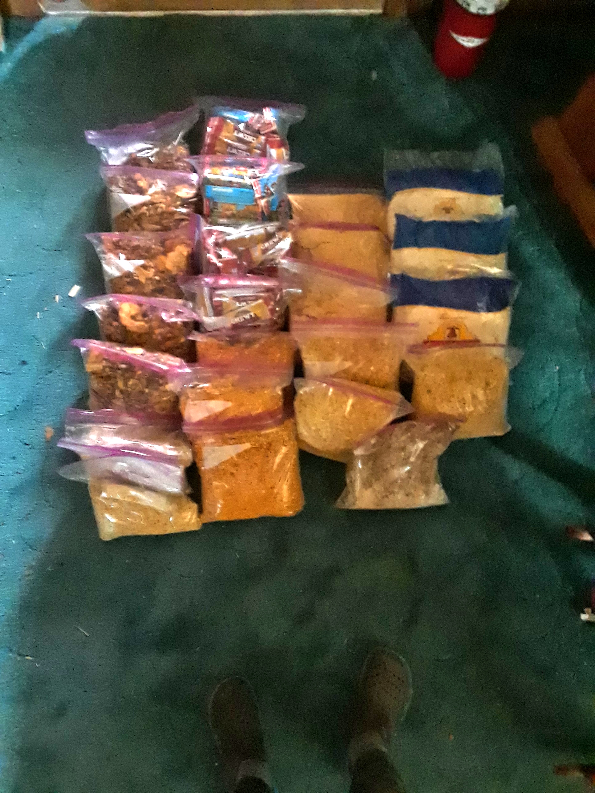
Pre-trip food pack: 11.25 pounds of, or 72 tortillas , 10 pounds of Knorr pasta/rice sides, 5 pounds of couscous with instant brown rice, 10 pounds of hummus powder/dried refried bean flakes, 2 pounds of coconut oil, 10 pounds of, or 180 granola bars, 20 pounds of homemade trail mix with every nut (except peanuts. allergy.), seed, and dried fruit under the sun, 10 pounds of powdered goldfish and chex mix, and a pound of creamered (Nido whole-fat dry milk) and sugared instant coffee. Close to 80 pounds of food for a month with leftovers expected.
The ride on the highway was great. I was just getting into the powerband at 80mph going up what the local boaters call “North American Hill”, and the weather was 45 degrees but sunny and clear, with stellar views of Arches National Park, the Book Cliffs, the Colorado and Green Rivers, the San Rafael Swell, the La Sal and Henry Mountains, and the vast expanse of the San Rafael Desert on the way out to the Hans Flat Road. I filled up on gas in Green River, then rode another 45 minutes until I turned onto dirt. It became immediately clear once I turned onto the unpaved road that this heavy bike would demand a much more cautious riding style than I am used to, which says a lot since, for the most part, I ride like a grandma. Regular road maintenance across high desert and sand dune country means the best it’s going to be still has patches of deep sand and long stretches of shallower sand. 40 miles to Twin Corral flats from here. This is actually where the adventure begins. About 4 miles in, the road carves a low spot between the dunes, and I approached it in the middle of 2nd gear, around 20-25 miles an hour. I am used to the bike getting squirrely under me through sand, but 2nd gear seemed like a happy medium of speed and torque where the unpredictable sways of the back tire wouldn’t take too long, and keeping my shoulders square ought to be enough to let the bike do what it wants until I quickly hit solid ground again. And hit the ground I did. The back tire slid out back and forth very quickly one time, I had control, and then it slid out hard left and the bike slammed hard onto its left side in the deepest part of the sand right on top of me. Oof. A stiff landing, but not quite enough to really knock the wind out of me. Still, my leg was pinned under the middle of the bike, which was raised enough by the H shape of the handlebars and the rocket boxes that I could dig a trench for my leg to get out easily and pain free. Quick head to toe check and all is good, but my windshield is snapped in half, and the visor on my helmet is broken off because I basically hit face first. The first time I tried to lift the bike back up, I laughed at the feebleness of my own attempt. Way too heavy. I took my backpack and the saddle bag off, and tried again. With stupid, adrenaline fueled, caveman, red-faced, hulk strength and a gruff exclamation that came from the gut, I lifted that fucker back up and held it there for a moment. A glance over the other side revealed to me that I was still up to the top of the chain in sand. And the stainless steel rack that the rocket boxes are bolted to bent where it attaches to the frame, pushing the left rocket box pushed in towards the wheel about 5 inches. Turned the key on, but I’m not getting power. I took a lid off one of the rockets boxes, and dug out the sand so I could set the lid down and prop the kickstand up on it, then took everything off the bike. If I was going to get this thing out of the middle of the road, or out of this spot generally, I needed to unload completely. Still, I don’t have a kickstarter, and it wouldn’t budge when I tried to push it out of the sand by myself. Thankfully, a family towing a camper trailer behind their Excursion stopped and mom and dad helped me get it onto solid ground again and even helped me push the thing down the hill to try to jump start it to no avail. I thanked them heartily for their help and told them to go on, that I had a SPOT GPS beacon to send a message out to some friends back in Moab that could pick me and/or the bike up if need be, plus 80 pounds of food, so I could afford to take my time. I did manage to jump start it, thanks to Ernesto, one of the ranchers out there who helped me push it down the hill one more time, and I rode around back and forth for about 45 minutes, watching the battery recharge and the lights start to work regularly. By now, it was dusk. It was nearly dark and getting cold, so I stopped the bike at the top of the hill past the deep sand, and shut it off. When I tried to restart it, it gave me nothing. Camp out here tonight, I thought, and take a closer look tomorrow. I hiked all my gear, 5 or 6 trips, just off the road into the dunes and spent that night telling myself I could have made it if I had been in first gear, but that I have been in this sort of position many times, where things go wrong in the middle of nowhere, be it at the beginning of the trip or in the thick of it, and mother nature forces your hand. Figuring this out is the trip now, so no reason to be upset or feel delayed. It’s a part of it. Morning comes and I’m up half an hour after sunrise reading a few pages from Infinite Jest over a cup of coffee and some trail mix for breakfast. I got my trail runners on and walked back to the bike without my puffy, because I then pushed that thing up the hill and ran it back down by myself, throwing my leg over, throwing it into first, and jumping onto the seat right as I let go of the clutch all in one clean move. Nada. By 1pm or so, I had to evaluate my options. I have enough food to sit here forever, but ultimately with how broken and bent everything is on the bike, combined with my now palpable lack of knowledge about bike mechanics, and the fact that I’m still 35+ miles from the Twin Corral Flats base camp with progressively more and more challenging road conditions, I wouldn’t feel safe riding very far in either direction. Sooner or later, I was going to need some help getting this bike out of here. So I did something I’ve never tried before. I pressed the vehicle rescue button on my SPOT device. The message was sent out to my boss in town, who runs a rafting and 4×4 tour company, and has all the necessary resources one could ever want or need for a vehicle rescue, as well as my parents so that they could stay up to beat, and my roommates, both boaters and therefore experienced in rescues of all sorts and well versed in shenanigans. “I’m fine, but the motorcycle is broken or won’t start. Need a fix or a ride”. The custom message was preset and could not be made more specific while in the field, and the people on the other end of that message could not message back. They got a GPS point and that message, and had to piece them together with the whole timeline to build the story of what happened and what they would need to bring out there. Meanwhile, I started shuttling all my gear, another 5 or 6 trips, from my camp in the dunes back up to the top of the hill, about a quarter mile away. An hour or two or three of rigging for the rescue on their end, then 4 hours of driving to get here means if someone shows up today, it’ll be around sunset, but any later than that and they’d probably decided they’d rather show up tomorrow knowing that I’m fine camping here for a few days. Sure enough, only about an hour or so after getting all my gear back to the bike, my roommate shows up in not a 4×4 or an AWD, but his Volvo station wagon, a message from the universe and indirectly from my boss that I had indeed done this the hard way by taking such an overloaded motorcycle. We loaded up all my gear into the back, and I put a padlock on the rear brake, not anticipating any swindlers to be hanging way out here, but if they were, they’d have to physically lift the thing off the ground to move it. No, no one’s going to bat an eye at it before I come back with tools or a way to tow it back to town, except maybe the dude who runs the grader, who rumbled by and waved a handful of times, or the ranchers running around trying to fetch their cattle before winter comes, but Ernesto would make them privy to the whole deal.
This all went down just before Thanksgiving, so by the time I went out to put the bike into the back of a pickup with one of my coworkers and get it into the backyard again, it made sense to chill, bake some bread, and be thankful for/with the housemates. Got lucky and one of the old boat hags in town let me borrow her Land Rover (!) to go back out there, because you know I’m young and go have fun. Day after Thanksgiving (and into the next day) I went to a rave that the base jumper crowd threw, the Turkey Boogie. So that was that. Left in the Land Rover on Sunday and this time the drive was a breeze. Made it to Twin Corral Flats, parked right at the top of Twin Corral Box Canyon as planned, and camped under the stars. In the morning, it was cold and frosty, but clear and I took my time to finish whatever final packing I needed to do, disconnect the battery on the Land Rover, take off just enough layers to feel cool when sitting still, and started walking around 10am.
Return to Forever: Days 1 and 2
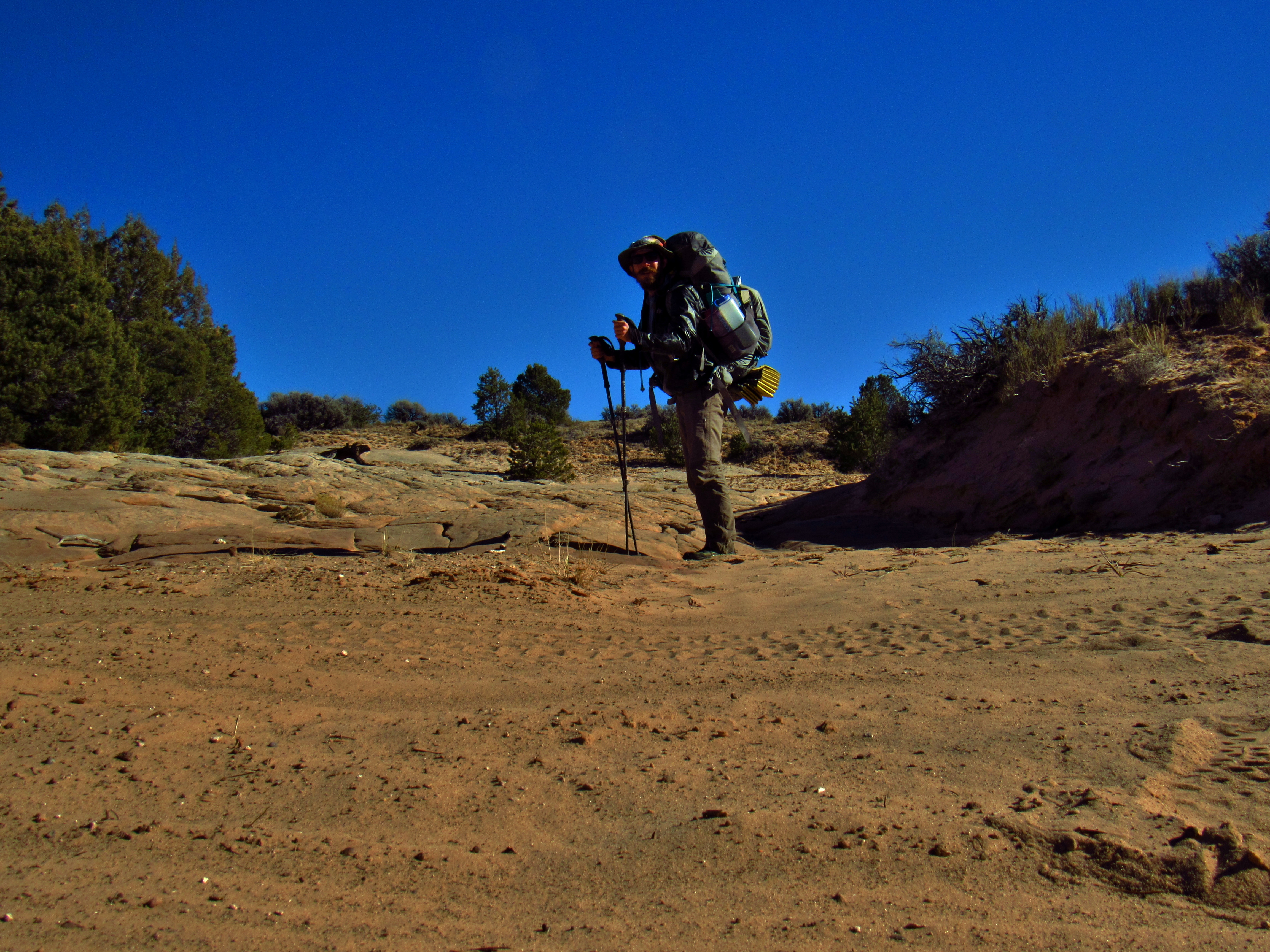
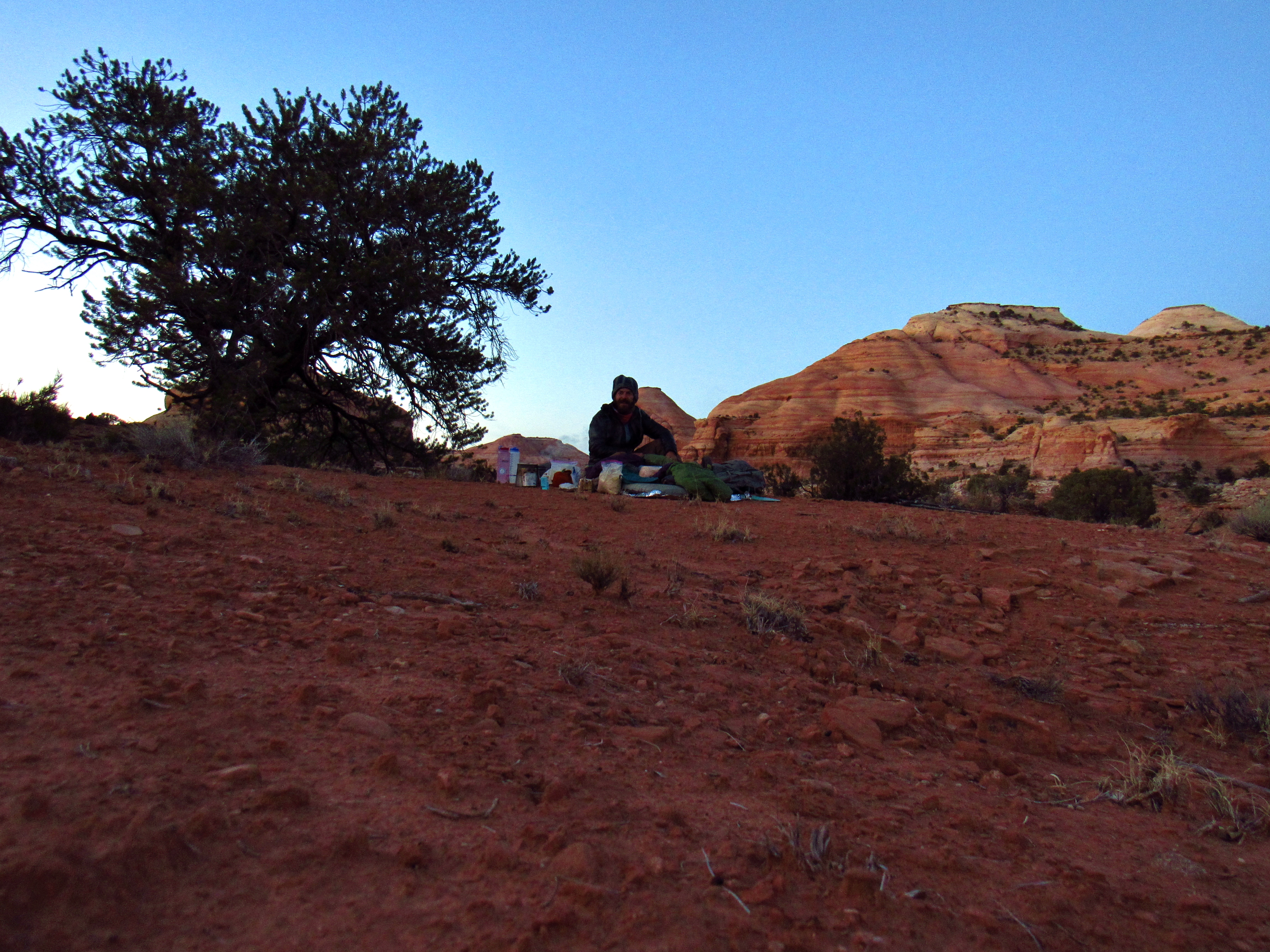
Heavy Pack Selfie
By the time I set up camp, I had walked about 12 miles. It’s nearly December now. The days are short, my pack is heavy, and it’s OK to go slow, I tell myself. And I mean it. It feels like an excuse, because I’m not fully immune to the internal and external pressures of expectation; an ultralight backpacker with as many lifetime miles as I’ve got ought to be able to go fast. But 10,000+ miles has also taught me to stop totaling up the miles and to start thinking quality over quantity. Or at least to try to not care. The impetus for this trip is multi-faceted. I’m here to explore the last section of Canyonlands I haven’t yet explored: The Maze. The perfect place to test my skills. I’m in one of the most remote places left in the US, for an entire month, without resupply or communication with the outside world, in the beginning of winter. I’m also here to reconnect and reflect after a grueling low-water season of long, unending consecutive days of work, and a hard break-up this spring, the fallout of which I am still dealing with, and which weighs heavy on my mind. I’m here for some time to think, to ponder, and some time to not think at all, to just do. I listened to Siddhartha, by Hermann Hesse on audiobook out of my phone’s speaker in my shirt pocket all day (so that I can still hear the sounds of the outside world, instead of listening through headphones), a book that, since I first read it in my Junior year of High School, has inspired me, reminded me to be present, and to consider the connections that I have, that we all have, with the ever-changing world. This time around, I find new meaning in the real and metaphorical river; that it is both a fleeting thing in the present and an infinite and eternal thing. Another season of whitewater raft guiding has given me the language to greatly expand on this metaphor and understand its depths: life’s eddies, its current, the riffles and holes and sand bars and ferry angles and CFS, and all the many variables that exist outside of ourselves that make our everyday choices seem small and insignificant, and impossibly meaningful and momentous at the same time. I think about all the lessons I’ve learned from backpacking (or more generally, from being alone and living slowly): the true difference between wants and needs, that by far most people are good and that you get what you give, that willpower is the most essential tool in one’s possession, that we are born from mother nature just like every other living thing in the world, and that our separation of “indoors” and “outdoors”, for example, is an illusion. I also think about the lessons I’ve learned from my time in the (to use an oxymoronic term) “real world”: the bottomless depths of love, the ethical imperative of helping others however you are able, the utility and fulfillment of learning and teaching, the reciprocal value of family/community, and the pitfalls of addiction, depression, solipsism, and violence. Not to say that I or anyone else have, or ever will learn these lessons permanently, but as Plato said, “an unexamined life is not worth living”. That is why I am here. To think, to see, to hear, to feel, to get a taste for the world and my place within it. I go to bed, having measured out and eaten my 15 spoonfuls of pasta sides, 10 spoonfuls of couscous, and 4-5 spoonfuls of bean powder, wrapped up into 2 tortillas as a dinner ration, with gusto, reading a few dozen pages of Infinite Jest until I feel my eyelids get heavy, and looking up at the miraculous dark-sky starscape of the Maze with wonder until they, my eyelids, close and I drift off into dreamworld.
Cowboy camp selfie
I wake up around 7:30. It’s coldish. Maybe high 30’s. There’s a little bit of frost on my outer sleeping quilt. 10 scoops of trail mix, 3 granola bars, and a pot of coffee for breakfast. A small flock of Pinyon Jays fluttered around in the morning sun, and I watched the sunlight creep down the North wall of the canyon until I was embraced by its warmth just after I finished my coffee. I shit twice, using disposable wag-bags to pack out my waste and TP. I’m walking by about 9, and I can feel, as expected, the wear that this heavy pack has done on my body just within the first day. My hips, shoulders, and lumbar are bruised, my hip flexors are tight as bow-strings, and I am sore in a way I haven’t been since I did my hike from Moab into the Needles District of Canyonlands NP 2 years ago. Like I was when I started my hike across the country. I almost couldn’t fit everything into my pack when I repacked it in the morning and rearranged some of my weight to redistribute the weight closer to my back and up a little higher. I go through the rigmarole of layering and unlayering to find the ideal system as the day warms up, and am pleased by my new DeFeet wool arm warmers and leg warmers for their superb warmth and ease of removal. I consider how my slow pace will effect the timeline of my whole trip, and am sort of banking on the fact that as I eat through my food and my pack gets lighter, I’ll be able to hike with fewer breaks and cover more ground each day to average out at my expected 15 miles per day. Still, it might be a good idea to drive out to Hanksville real quick after this loop to at least check the weather in case a spell of -20° is going to come through, which is possible, and which I am not truly prepared for. It’d also be a good chance to make a couple phone calls to the important people in my life and let them know that I am OK and happy, more than I can with my preset message on the SPOT device. The thought of bailing out to Hanksville for a quick stop is coupled with doubt. Surely, I think to myself, I have the necessary gear and skills to handle whatever situation is thrown my way, even if it isn’t comfortable or fun, and absolute worst case scenario, I have the SPOT device. Plus, I came out here to be spend some time alone to confront my doubts and fears and self-concious anxieties, whatever they may be, and bailing out might give me an excuse to submit to them, give up and just drive back to Moab. Perhaps if I just stay out here, I won’t afford myself that opportunity. Checking the weather is a smart choice, though, as far as risk management is concerned. It’d give me the chance to know what’s coming and make an educated decision based on that information. Well, I’m still more than a week away from that point anyway, so I’ll think it over again a few times along the way and make the decision when it comes to that. There’s yellow-flowered rabbitbrush everywhere, gnarled and flaky pinyons and junipers up on the hills, mormon tea here and there, and plenty of tan-to-black biological soil crust (AKA crypto), though it doesn’t look like the prolific and psychadelic, multi-colored stuff I saw back in October when it rained and all the algae and mosses were photosynthesizing like gangbusters. I walk steadily, and acknowledge my doubts for what they are and ask myself what they signify. Self-conciousness. I don’t feel as strong as I have in the past, and I definitely don’t look it either. I don’t have a defined sixpack anymore, and I’m going bald in the front. Balding at 24? Really? Yes. Really. It’s part vanity, part lack of confidence, and ultimately a useless set of thoughts. Identifying what those thoughts mean helps me get over them- a tool I learned to use from hiking across the country, and have practiced in meditation quite often since then. It doesn’t usually resolve itself immediately, doubt, but acknowledging it helps me assure that I make positive decisions and avoid the traps of indecisiveness, or worse, inaction. I will go to Hanksville to check the weather. Hubris is what kills young dudes like me in the backcountry all the time. Plus, sure, I didn’t run or do as many calisthenic workouts this season, but I did play a metric shit-ton of guitar and my singing voice has gotten a lot better from busking on Main Street, playing open mic night just about every week, and from the countless nights on the dock or around a campfire with friends.
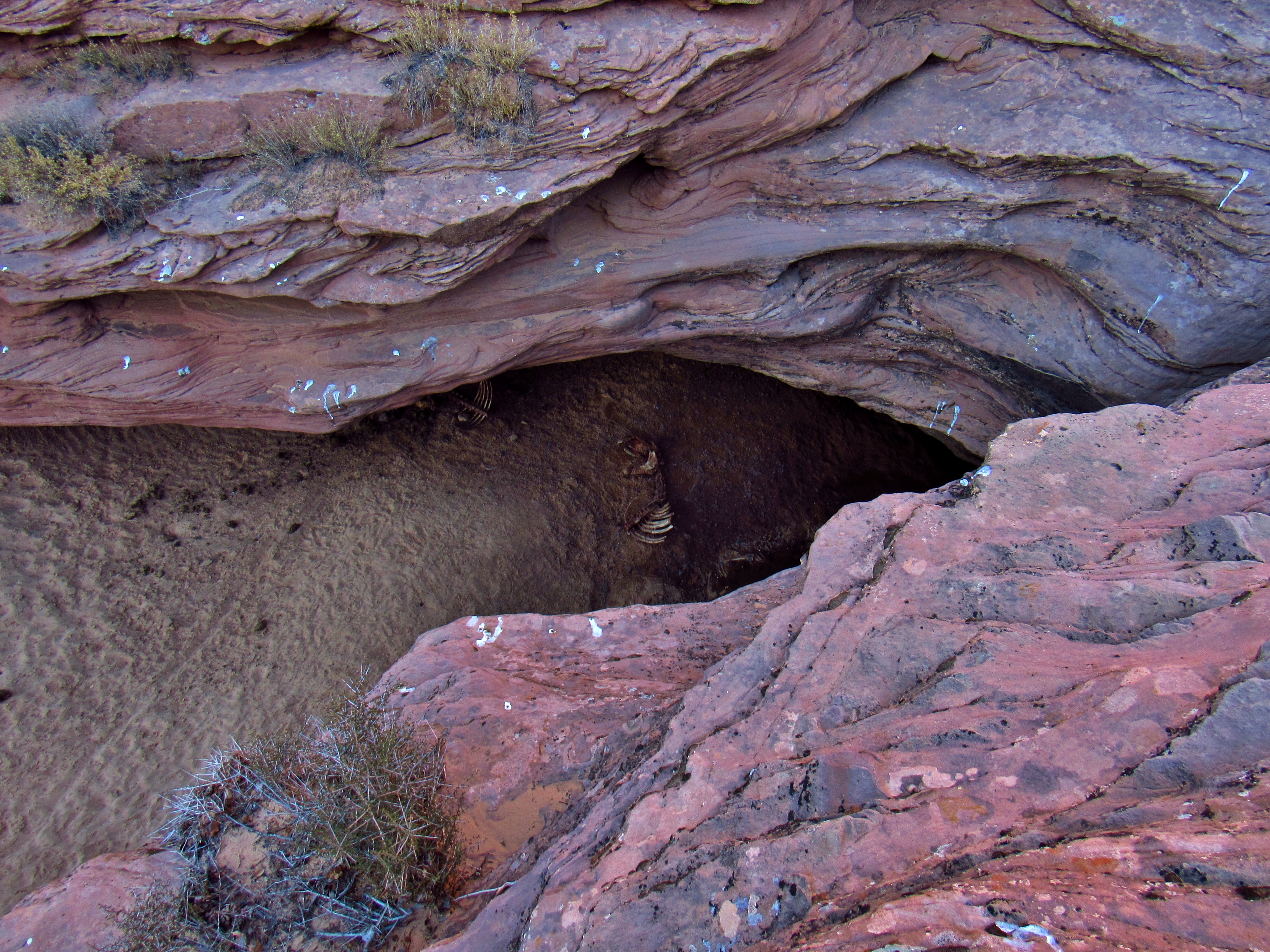
Burro Skeleton in the Wash
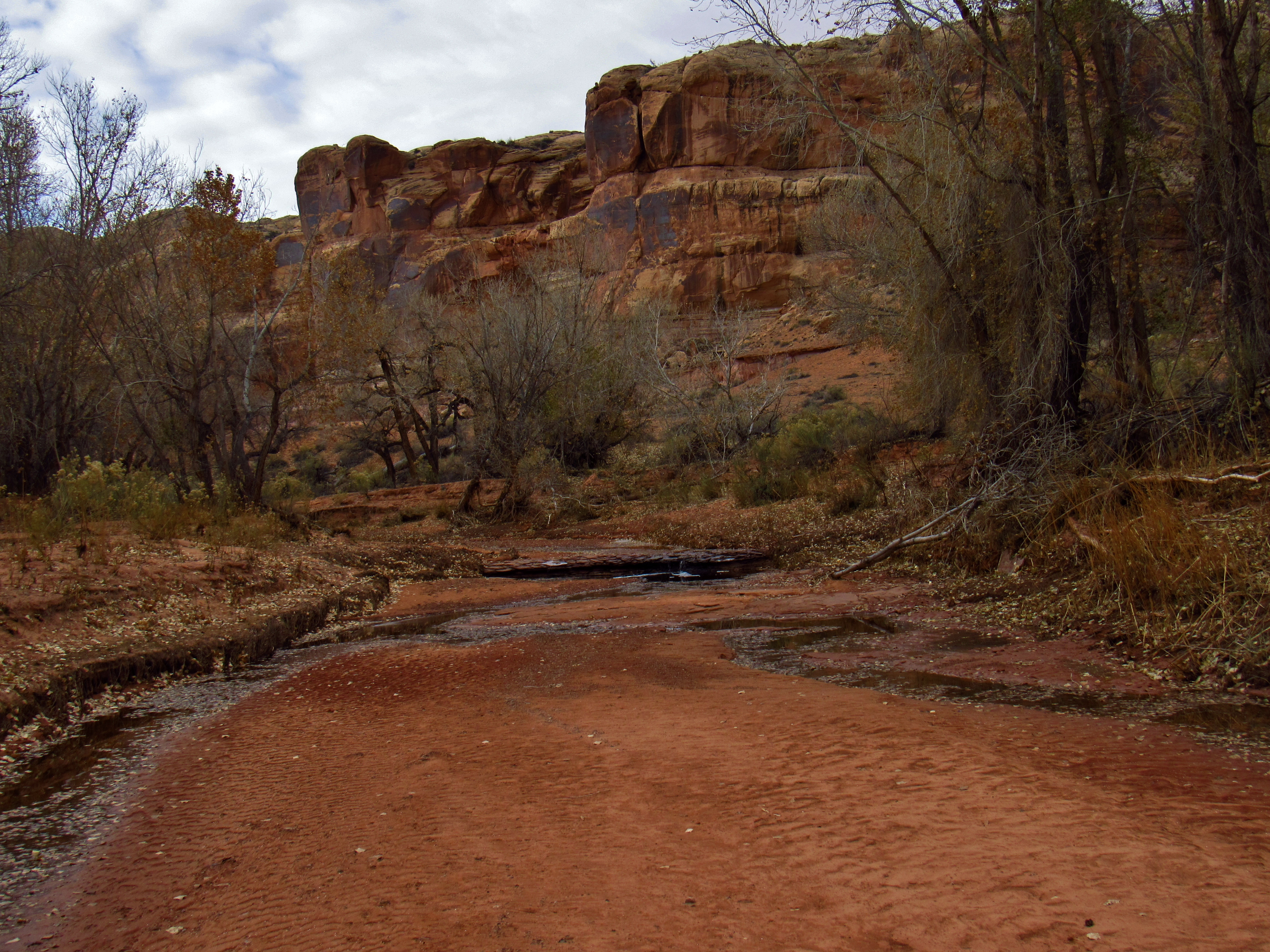
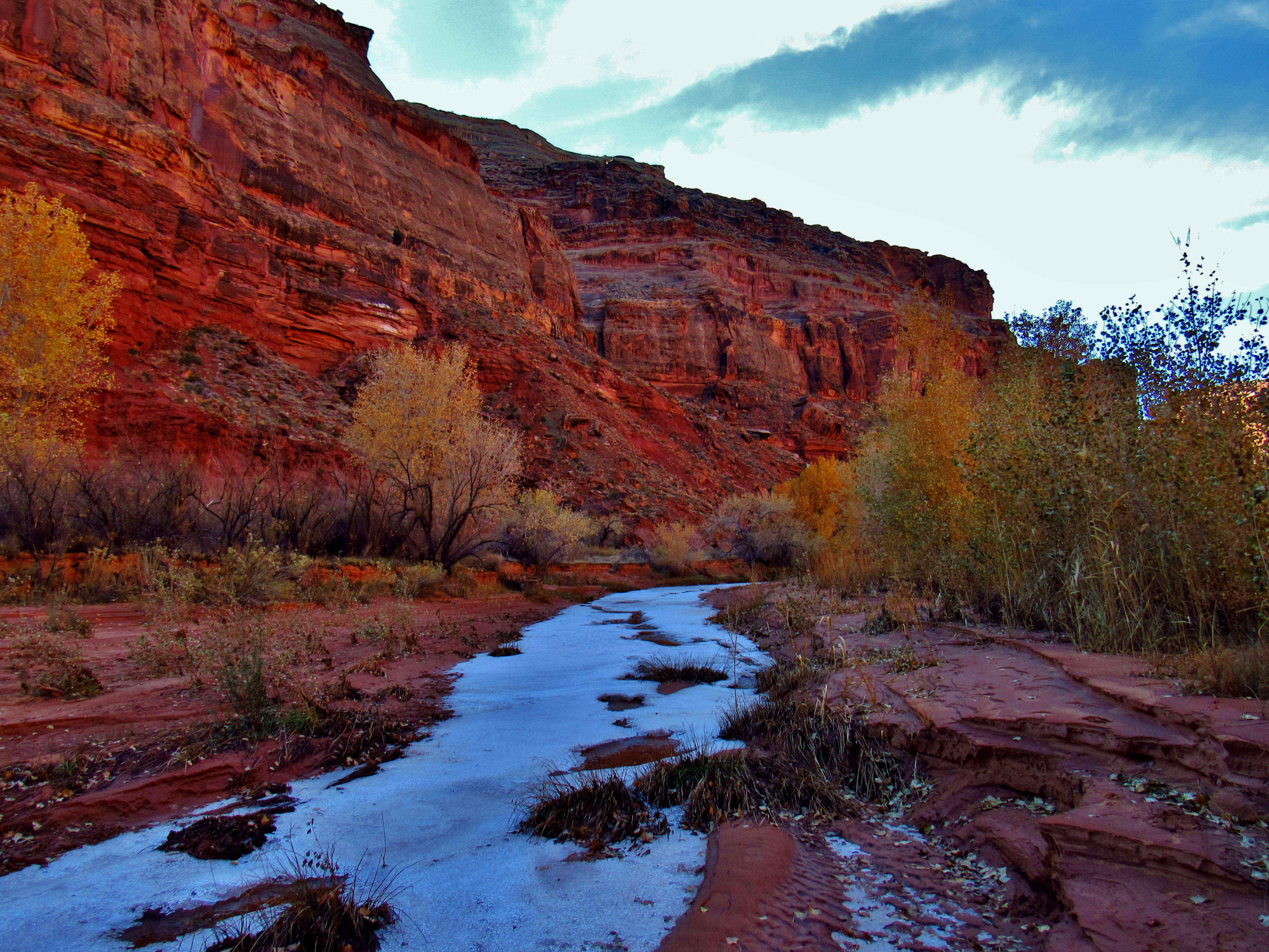
The terrain in the wash is varied. Mostly deep sand, frozen into beautiful fractal designs from the last time water flowed through here. There’s solid sandbanks deposited 5 or 6 feet above the floor of the wash, stuck into hollowed out pockets of sandstone in 30 foot wide walled-out sections of a bend. I imagine how much water would have to flow through this canyon to bring sand up that high, and it excites and terrifies me to think of it. It’d be a hell of a thing to witness, but only if you’re out of the flood wall’s way when it comes. As of the end of November, the wash up in this part of the canyon is dry, and I can see that somebody else has hiked up here within the past few weeks since the last rain. There’s one set of footprints that come and go where the sand was able to hold on to them for a while. Who would’ve come up this far? I wonder. Parts of the wash reveal the bedrock beneath all the sand, and there are a few pourovers I have to navigate around to get down and back into the wash below. As I stand at the top of one, and scout out my route down the slickrock staircase on the North side of the pourover, I see a burro skull still attached to a 2-3 foot section of its spine with a few ribs still hanging on, totally stripped of flesh, sitting in the mud at the bottom of the slotty pourover. It must have gotten stuck and died trying to get out of the thick silty, goopy mud. There’s a population of wild burros down here, left over from cowboys that used them to haul gear across the desert, abandoned when the work was done, and resilient enough to survive and repopulate over the past hundred years or so. They must be kinda fucked up, genetically speaking, given that some of those generations must have been incestuous. Another mile down, there’s a large frozen pool of water hidden behind a wall on the South side of the canyon, with water flowing down from it maybe a hundred yards or so before it goes underground. The pool is fed into the top by a clear and completely frozen spring, which looks clear and is flowing at a decent rate. I set my pack down and walked up the little streamlet to check out where it was coming from, and found a stunning frozen sheet of ice that fanned out across a slab of slickrock. I filled up on enough water to get me through the rest of the day today, and half of tomorrow, encouraged by the sight of more than a few frozen puddles in the dark places. I figured there would be water in the canyon with how much it had rained late in the season, but there was really no way to be certain, since hardly anybody ever goes down here.
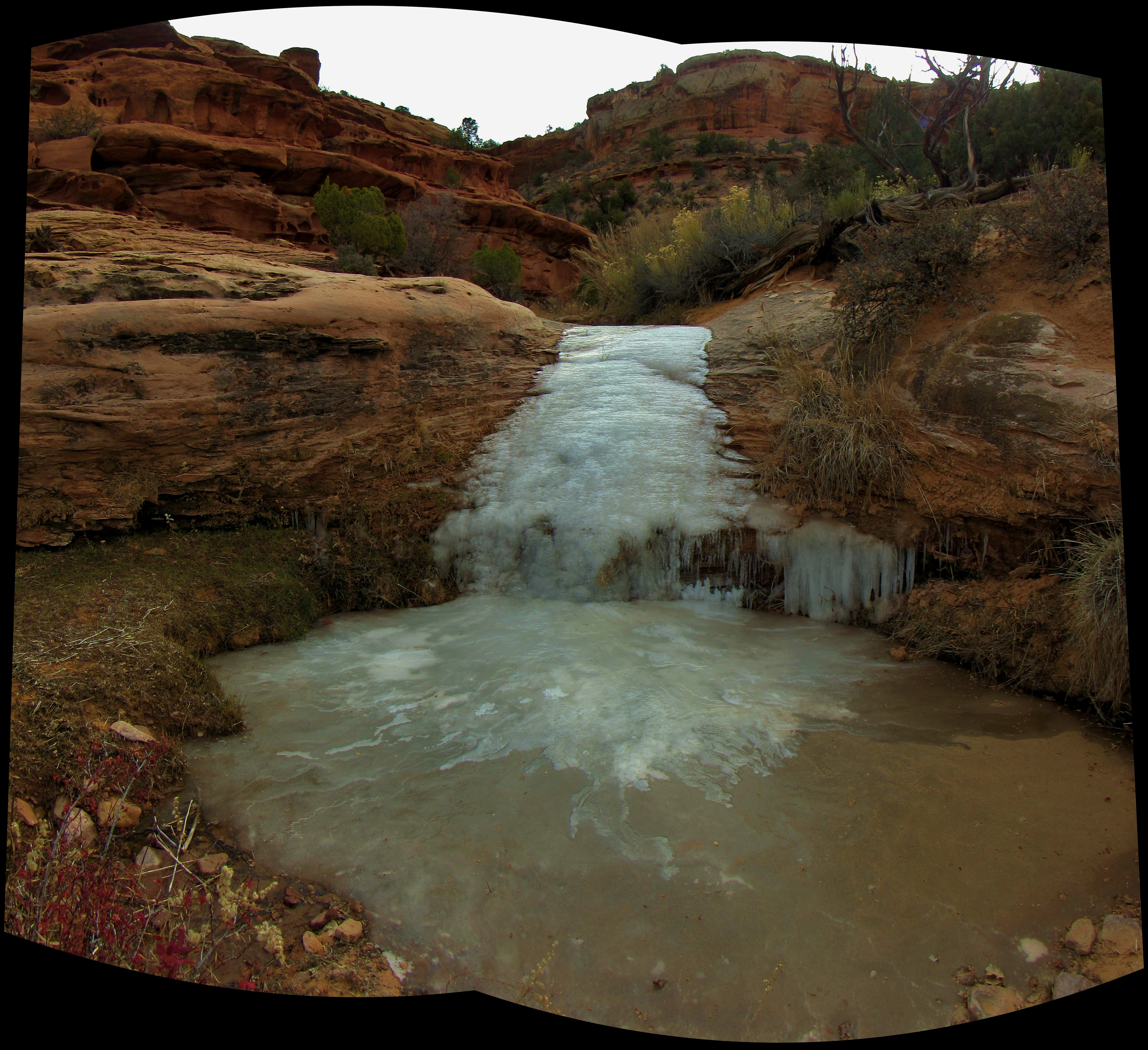
Frozen Spring Waterfall Panorama
A quick rationed snack: 10 bites of ChexMix/Goldfish powder, 10 bites of trail mix, 5 granola bars, and I chugged a liter and a half of electrolyte replacement drink while I was next to the water source. A few miles later, down the wash I saw some really perplexing and beautiful cross-stratification, which is basically where individual rock layers within a formation are set at angles to each other. It’s probably easier to see than to explain. Notice the X shaped crossing in the rock layers slightly above center in the photo. I still haven’t figured out what might cause such a seemingly symmetrical and continuous. If you have any idea, I’d love to hear it.

Cross Stratification
And a few miles after that, I was floored yet again by a very large Barrier Canyon Style pictograph panel high up on a wall of the Wingate Sandstone, a formation famous for its sheer cliffs and black stains of oxidized Iron and Manganese colloquially referred to as “Desert Varnish”. There’s no way to no with absolute certainty how old this panel is, or what person or group(s) of people painted it, but its safe to say that it’s around 2,000 year old, and potentially much older. And although it has faded some, it is still clear enough to see from a distance, especially standing prominently high up on the wall. Notice the rectangular body shape, and the horns on some of the human figures, and look for animal figures here too. I see at least one bighorn sheep depiction in here. I encourage you to click on the photo and pull it up in full size. All the images I put on the website are in full-resolution, so once you open the file, you can zoom in and get a really good look and what’s here. Again, comments and ideas on what you see are welcome.
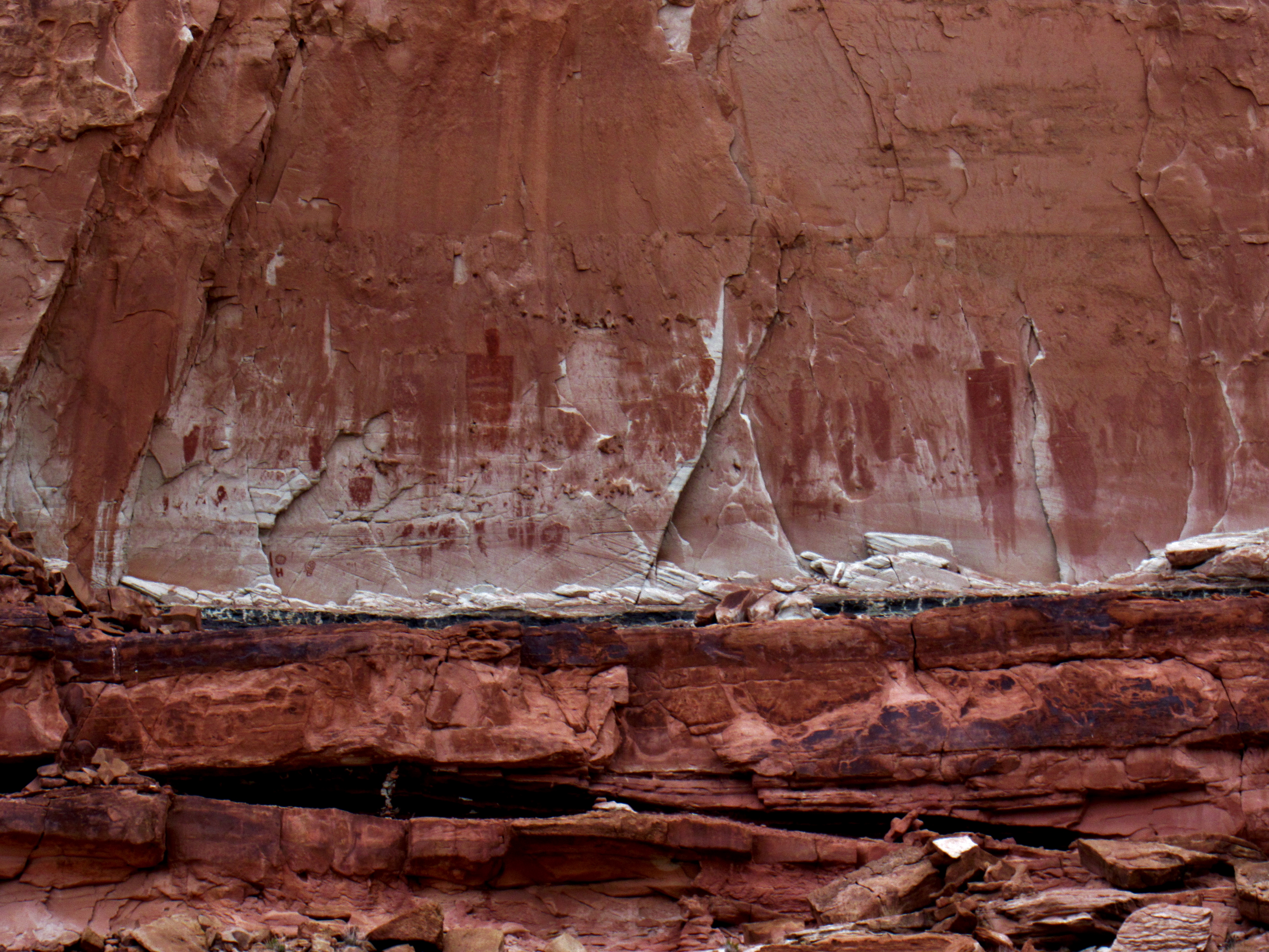
Unmarked Archaic Pictographs
After about 10 miles, I set up camp on a shelf above the wash at the mouth of Blue John Canyon where it feeds into Horseshoe. Blue John Canyon was made (in)famous from Aaron Ralston’s arm-cutting-off debacle that was depicted in the movie 127 Hours, the details of which, and the boat-load of corresponding opinions can easily be found online, so I won’t really go into that much, but again, it might give you a sense of where I was if you know nothing else about this place. By camping at the mouth of Blue John, I was still in BLM land, where it is legal and free to camp, but I was very close to the boundary of Canyonlands National Park, where I would have to get a permit to camp. This way, I could get up in the morning and walk completely through the park through the the other side and camp again in BLM land without dealing with the permitting process. The likelihood of someone busting me for a camping permit out here is low, but when it is easy and not an inconvenience for me to follow Da Rulez, I will. It was cold enough today that I wore my gloves and my thin rain jacket most of the day, but was alternately slightly too cold or too hot depending on whether or not I was in the shade. Rationed dinner, this time pasta side first, boil 5 minutes, bean powder next, boil 3 minutes, cous cous as needed to absorb the excess water. I listened to Moby Dick by Herman Melville on audiobook all day, another one of my favorite and most inspirational books. I was, as always, captivated by his poetic imagery, and delighted by his 19th century, sarcastic and very dry humor. I feel a kinship to Ishmael, who is driven to the sea as an alternative to suicide or grumpiness (see the dry humor?), and finds himself in such a strange and motley set of circumstances, but learns from them by accepting his fate and trying only passively to dictate it. He is an observer, a listener to the world, and a friend to most. Reminds me of backpacking and boating and the wild cast of characters and situations in which I acquiesce. As I read before bed, I heard very loud braying down the canyon, and looked up to suddenly see 7 burros, alive, lazily strutting up and down the shelves on the other side of the canyon. I watched and listened for a while, but when it was fully dark and I was ready to go down, and they were still being noisy, I said the first words I had spoken aloud in 3 days, loud enough that it echoed through the canyon, not mean or hostile in any way, but lovingly, sort of like you would tell a best friend if they were drunk and digging themselves a conversational hole. “SHUT THE FUCK UP”. They did.

Burros
The Land of The Horned Gods: Day 3
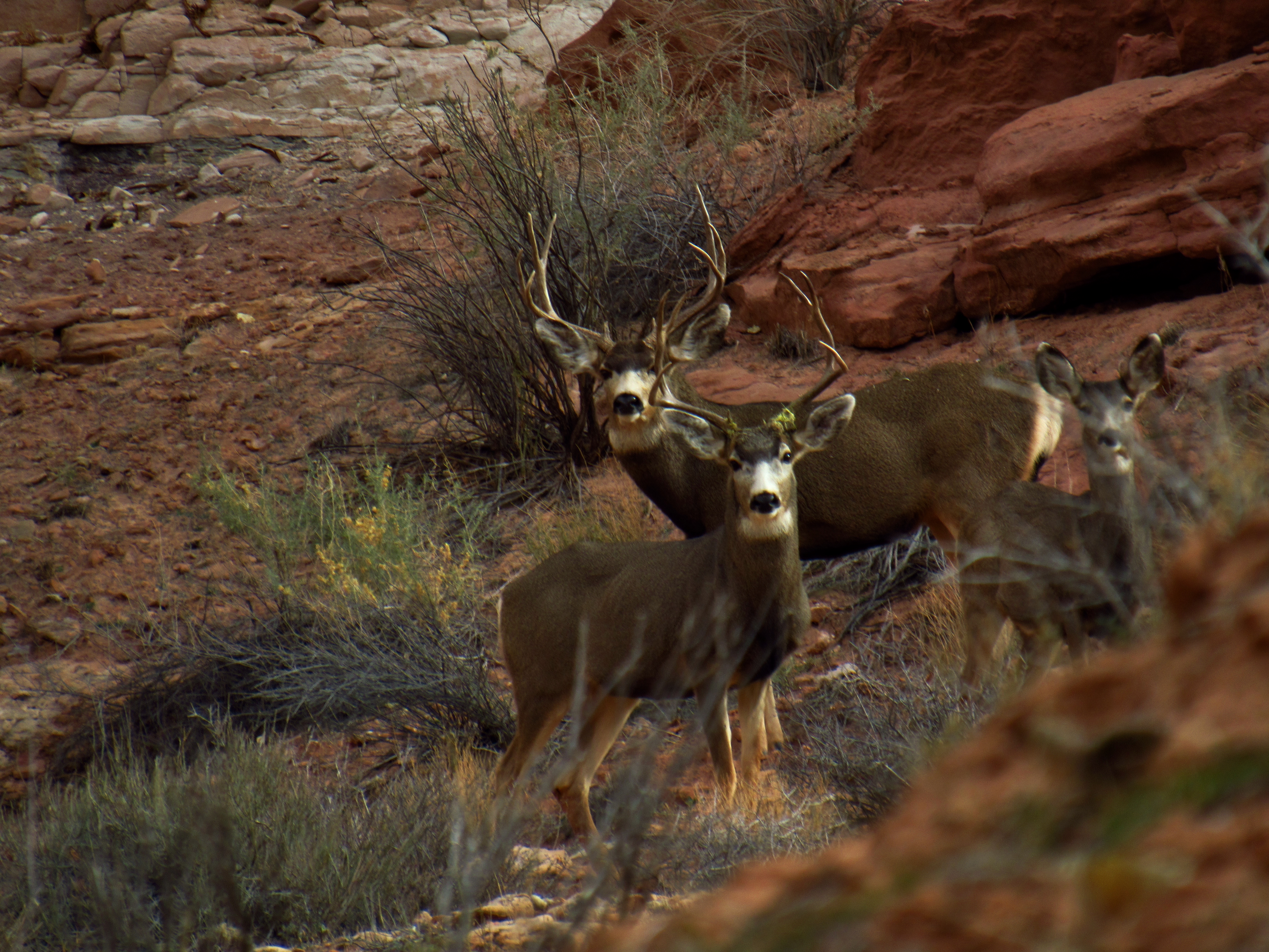
Mule Deer
A 6 point mule deer buck, such a dark brown it was nearly black, trotted across the wash, then picked up just enough speed to stride halfway up a steep sand embankment, easing back into the last 3 or 4 steps to get it to the top. Its cloven hooves seemed to distribute its weight well enough that the sand stayed solid under its feet, whereas I would have had a tough time of it even without a pack on, and an especially arduous and slow effort with the pack I’m carrying now. It looked back over its shoulder, took an easy, careless deep breath at the top, and disappeared over the other side out of view. It was a specter, ethereal and all too real. I woke up from a dream last night to set up my tarp over my cowboy camp, tightening the guylines as much as I could with my stakes held unreliably by the sand. The billowing clouds, dark, close, and steadily moving, gave me apprehensions about cold rain or snow. It ended up staying dry through the night, but it was a little colder this morning and the ominous clouds were still there, silent, bitter, and grey. I spent some time looking at the NatGeo fold out map last night studying the nearly infinite side canyons and wondering how long it’s been since someone’s been there, if anyone ever has. How long would it take to really thoroughly explore them all, I wonder? Logistically, it would take a few years, given that you only really get 7 or 8 months of the year at the most where you can reliably embark on a self-supported long-term backpacking trip without it almost killing you by the end of day 2. Still, the cumulative walking days alone would add up to a few years even with a healthy pace. Like Ishmael, I am drawn to the daring enormity of the world, by the want to hear and see it all, to know it all, and to live presently and cohabitably within it. But like Ahab I am tormented by it, pridefully and foolishly striving to attain it, to own and conquer it, despite having so much back on land to cherish and revel in. “For now, since by many prolonged, repeated experiences, I have perceived that in all cases man must eventually lower, or at least shift, his conceit of attainable felicity; not placing it anywhere in the intellect or the fancy; but in the wife, the heart, the bed, the table, the saddle, the fire-side, the country” – Ishmael, Chapter 94. Is this irresistible drive I feel truly something that I want, or is it merely aspirational? When, if ever, could I find contentment in resigning to a land-lubbers life? Or, like Ahab, will I chase it insatiably until it kills me? Maybe I’m being hyperbolic, I tell myself. It’s not so cut and dry. I’m young and I have plenty of time to commit to exploring before I need to consider “resigning” to anything. Plus, it’s not like I can only have one or the other. There are plenty of ways to compromise if I want to. A warm pot of coffee keeps only the palm-side of my fingers warm, but I can still feel the chill of the ambient air against my knuckles, and I sit, wrapped up in my sleeping bags, staring out at some intermediate point of open space at nothing in particular for an extra moment, able to acknowledge these thoughts and feelings, but deeply unable to reconcile them. This is my white whale, and I wonder if fate dictates that I be swallowed by it.

Cowboy Camp at the Confluence of Blue John Canyon
Two 1/4″ parallel steel cables, bolted to the walls on either side of the wash, a couple hundred 8 or 9 foot wooden pickets fixed between them all in a row, wire mesh in the gaps against the walls, and a sign on both sides pointing hikers to use the wooden stile. This is the fence in the middle of nowhere that delineates the boundary of the BLM and the NP. It must have been a hell of a project to get all the supplies and tools and muscle down here to construct this thing, but it was built to keep the burros out of the park, so as to cloister their wanderings and prevent them reeking any more havoc on the fragile desert ecosystem than they already have, and so it must be strong. The Horseshoe Canyon detached unit was added to the park in 1971 along with The Maze, the Land of Standing Rocks, Davis and Lavender Canyons over in the Needles, was part of the same move that switched Arches from a National Monument to a full-blown National Park (many thanks to Bates Wilson), and was specifically designed to protect the rock art and archaeological artifacts found within its borders. Despite the 2.5 hour and 4×4 recommended drive from Moab, plus the 7 mile round-trip hike with a 780 foot descent right at the beginning (and the climb back up it at the end of a long day), the trail that snakes down the western rim of Horseshoe Canyon has become a pretty popular hike for tourists, and can be done as a ranger-guided tour, or through a number of outfitters across Utah, mostly in the Spring and Fall. It’s not hard to see why people have been congregating here for such a long time; Barrier Creek provides an almost year-round water source, which means a reliable place to get a drink and cool off, and lots of big old shady cottonwood trees. Plus, this part of the canyon is on a giant syncline, which means the rim is much closer to the wash than almost anywhere else along the entire length of the canyon, making it the easiest place to get in and out on either side, and also bringing the desert-varnish-stained cliffs of the Wingate Sandstone right down to the floor of the wash, where finding a canvas-like flat face of rock would have been easiest to find for ancient painters. It is a true oasis in the middle of an exceptionally barren, convoluted, and remote landscape. Soon after climbing over the stile and rounding a corner into a lush grove of cottonwoods, where the water of Barrier Creek first emerges from a flowing spring on the north side of the canyon, and the ground is the yellow, brown and orange freckled color of leftover leaf-litter from Fall, I catch a glimpse of another mule deer flee from sight over a sandy hill to my right, this one a lighter colored doe. I stop, get my camera ready, and walk softly, holding my trekking poles under my arm as I round the corner in its direction. There are four of them in a group- the doe, and three bucks, two 8 pointers and one 6 pointer. They climb a few feet up the rocks to gain the high ground and look back at me just long enough for me get a few good photos of them posing. I talk to them endearingly, letting them know that I mean them no harm and only wish travel in their direction, and am willing to give them more space is they so desire. But so for about quarter mile they lead me through the canyon, waiting for me to catch up every few hundred yards. I make a point to walk to the other side of the creek to avoid stressing them out more than necessary, and right around the time we reach the point that the bedrock is exposed again and the water funnels into a miniature, half-frozen waterfall, I lose sight of them. It’s a good spot for me to refill on water, and I carefully walk across the micro-thin sheet of ice towards the middle of the creek, and quickly fill my nalgene bottles from the pourover. The water is brown from tannin, and obviously quite cold, but tastes just fine, and I am delighted to see this much of it down here. The only other times I’ve been in Horseshoe Canyon were within the park, and most of those times there was no water at all in Barrier Creek.
Barrier Creek in Canyonlands National Park
I keep my eyes peeled for rock art, looking for spots that would have made a comfortable place to rest, and/or a nice flat painting surface. In my state of revelry, having lost an awareness of the normal pace of time, I seem to just stumble right onto The Great Gallery. I had been been apparently so focused on searching for potential rock art sites, that when I found myself suddenly standing before it, it surprised me, like a well-camouflaged snake slithering quickly away from right between your feet. I gathered my wits about me, and walked up to the little viewing benches and the adjacent Park Service ammo cans that hold a pair of binoculars and a slew of informational print-outs on general and specific archaeological information regarding Barrier Canyon Style rock art and the Great Gallery. As I am walking up, a group of half a dozen folks all +/-15 years of retirement age are just turning around and heading back towards the trailhead and their vehicles another 3.5 miles downcanyon. We exchanged greetings and the most gregarious of the old men said to no one in particular, “funny seeing anyone else down here!”, to which I scoffed, “You’re telling me. I haven’t seen anyone in 4 days.” The whole group of geriatrics wowed and made soft exclamations amongst each other and the old man asked me the oddly worded, “so where are you staying?”, and all I could think to answer was something like, “You mean tonight specifically, or in general? Because, I mean, I’m on a long backpacking trip, so I started all the way up at the top of the canyon and am gonna walk through to other side of the park so I can be back in the Wilderness Study Area on BLM land where I don’t need a permit and can just camp wherever.” Really, if I were to answer his question literally, I would have said that in fact, by definition I was not staying anywhere, as the whole point of backpacking is to move rather than to stay, but even though I wasn’t sure he knew what he was trying to ask, or whether it just came out worded kind of strangely, I had assumed he was asking about where I choose to set up camp, likely out of curiosity of whether or not there were designated campsites down here, and if not where one would go otherwise. His response: “Wow.” One of the ladies flashed a pearly, lipstick-lined smile at me in a way that made me feel like she was more stoked about the story she could tell her friends about how they met some amazing young man traveling with a big backpack in the middle of nowhere who said he was going to be out for DAYS, than she was about the actual trip itself, despite the fact that she and I never actually exchanged words, and that the whole interaction between myself and her group was basically a 60 second small-talk exchange with the one rad-granddad. When they left, I walked a lap along the fence, taking time to really study each figure intently, to consider its place within the whole panel, and to take a chance to back up and see the thing as one piece too, where it is easiest to notice the visual depth of the Holy Ghost Group (smaller figures appear farther away, bigger figures appear closer). I shot the panoramic photo posted above, which if you didn’t take the time to look at before, seriously go do it now, and walked back to the ammo can to pull out the binoculars for a closer look. I hadn’t even noticed, but a younger, maybe 30’s hippie couple- girl with dreads and fedora, guy with long hair, baseball cap, and a clean face- was now sitting down in the wash, appreciating the view of the panel from afar. I took the bino’s out of the ammo can and looked closely- the dog, the hunter, the ascending sheep, the artist, the holy ghost, the warring dudes, the carved but unpainted bighorns, the line of tiny people, the eagle-shouldered dude. I took a big gulp of water, grabbed the straps on my backpack, and had to lift it onto my knee first to be able to swing it around onto my back without keeling over. I walked down towards the young couple and said hello, asking them if this was their first time seeing the Great Gallery, which it was, but as we chatted, it also became apparent that these two were not noobs to rock art. The dude mentioned Optically Stimulated Luminescence before I could, and explained that they are currently on a long road trip to view and photograph rock art all around the country. Their next stop would be along the Oregon Coast. Turns out we have a lot in common: we’re boaters, we have some common friends, and both value living simply and sustainably. We share jokes, they give me some really delicious clementines that make my salivary glands tingle, and we exchange personal information, even though I personally won’t be able to do much with it until nearly a month from now. The clouds had thinned out in the morning so that for a while while we were talking it felt very pleasant to sit in one spot and talk, but now the clouds were rolling back in and it was starting to get cold again, even though it was mid-afternoon and ought to be the warmest part of the day. I bid the couple farewell, and started moving again with my arm warmers, button down shirt, and rain jacket on, which I would wear the rest of the day. I walked past the Alcove Gallery and the High Gallery without really stopping for more than a glance, having been to these sites many times, and eager to make some more miles today, and by the time I passed the turnoff for the trailhead, the sides of the canyon began to rise back up high above the wash, signifying the end of the syncline and the beginning of new and unexplored territory for me.

Bedrock Wash
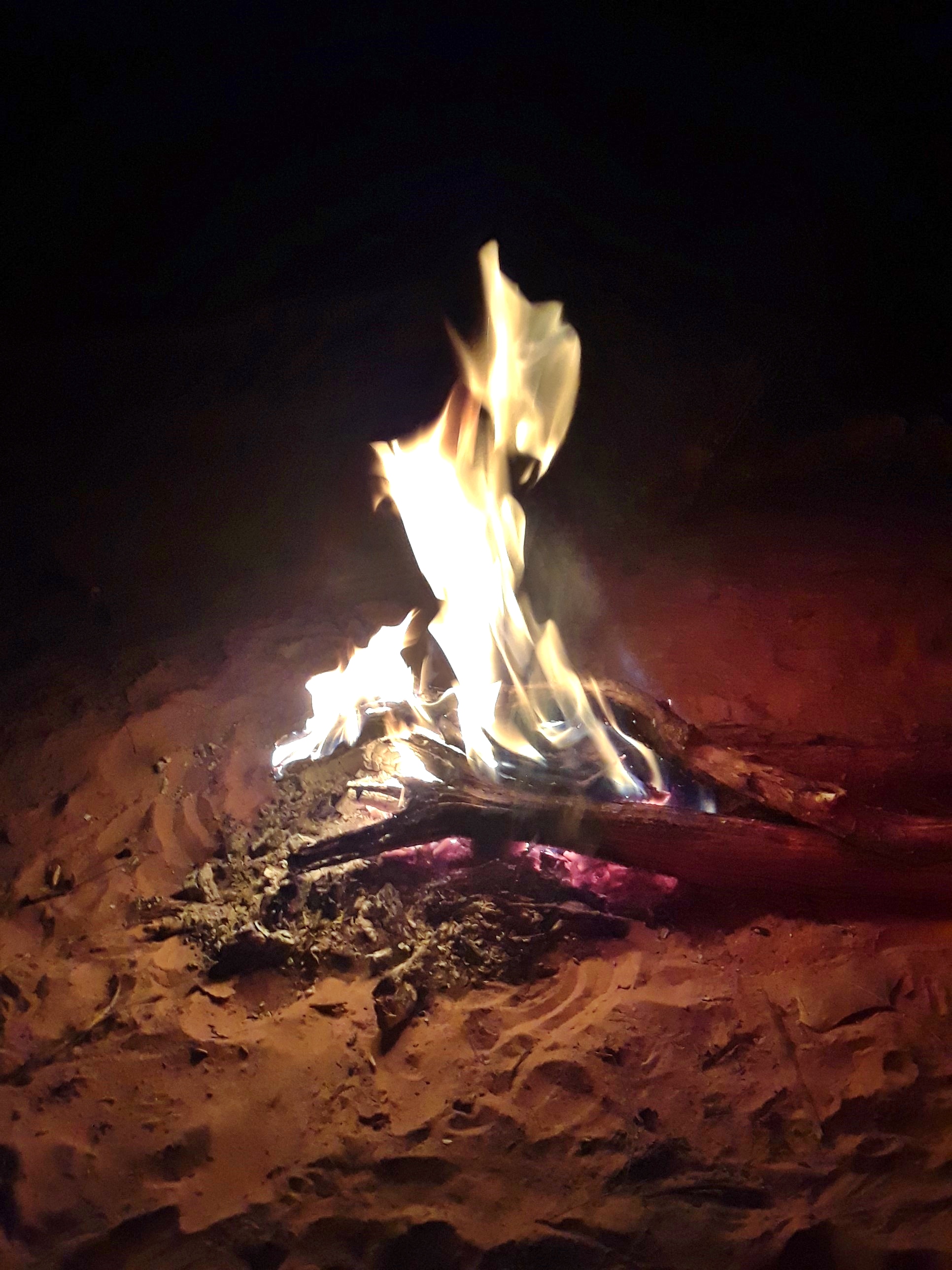
The canyon narrows, the floor is entirely exposed bedrock with eroded slots and frozen potholes, 270° slickrock staircases, and cliffy pourovers to route-find down, all making for a bouldery-muddy-constant-creek-crossing-bush-whackingly good time. I was amazed at all the places the mule deer and burros could go, having seen their shit and footprints in some seriously precarious and exposed places among the boulders and steep slickrock. And there were still a few human footprints in the mud here too, though it was hard to tell how old they might be. The narrow bedrock turned into a wider gravel wash, and the canyon walls continued to grow until you could only really see how tall they were if you got an unobstructed view down a straight part of the canyon, so that your angle of perspective allowed you to see the full range of rock formations, Chinle to Navajo. There was a wide variety of plant life in the wash, and some really good patches of biological soil crust, so I spent an hour or so taking photos of every different species I could find in one relatively abundant part of the canyon, intending to spend time identifying and compiling information on them after the trip. Maybe another 2 or 3 miles downcanyon, I found a beautiful campsite on a bedrock shelf above the wash where there was still trickling water, started a fire, made my rationed dinner, and read some more before bed. I didn’t listen to podcasts today out of respect for such a sacred place. Instead I listened to the sounds of the canyon, the rustling cottonwood leaves, the calls of the rock wrens, the burbling of Barrier Creek, the high-frequency crunch of sand underfoot, the sounds of my own breath and heartbeat, and more than anything, the all-encompassing, impenetrable silence.
-

- Canyon Grape
-

- Winterfat
-

- Threadleaf Groundsel
-

- Threadleaf Groundsel
-

- Rabbitbrush
-

- Biological Soil Crust with Cyanobacteria and Short Twisted Moss
-

- Fremont Barberry/ Mahonia
Opposing Forces: Day 4
Campfire
A panicked mother; pods of whales aggressively beaching themselves in tropical sands; jumping extraordinary parabolic gaps on a motorcycle with 30-40 seconds of airtime, wallriding, flipping, and rolling over incredible desert fjords. It was a warm night, relatively speaking, and like watching the last faraway flash of a mirror as it descends into a black hole, I woke up to the desert sun. My mom’s resort wedding in Jamaica next month, my white whale, and the flow of movement within and without a fluid, intangible existence: a 10 hour silent sleep dream. The fire was dead, and I was back in the real morning world. I left the wagbag open, expecting to take a second shit after instant coffee/muesli porridge. I was right. The canyon narrowed significantly around the next bend, towering walls on top of towering walls on either side, and random variable stacks of boulders, cobbles, rocks, gravel, and eye-poking shrubs in a choked corridor. Holes were skewered into my thin rain jacket while moving slowly and carefully through the challenging, slow, and tumbly wash. Clever navigation is required, primarily for the determining the specific location of creek crossings: stay on the inside of the tight bends where there are more shelves and sandbanks, and try to cross where the willows and tamarisk aren’t. Not only do they poke, but they hold onto the banks too well and the water between them digs a deep canal that is often too wide to jump across, even without a pack, even if you could get a running start. There are shoeprints even here, where the path of least resistance necessitates bushwhacking and gymnastic boulder hopping, though these shoeprints are often coupled with deer tracks that were clearly followed. The crypto is very mature, and quite happy with the recently abundant and available water, as shown by the dense patches of frost-heaved, miniature black castles of cyanobacteria-swarming crust, generously spotted with brilliantly colored lichens and green moss. A sharp-shinned hawk ruffled its feathers from the branch of a tree in a cool, cloudy light, wise to what I could only perceive as intermittent, hidden birdsong echoing across the walls of the canyon.
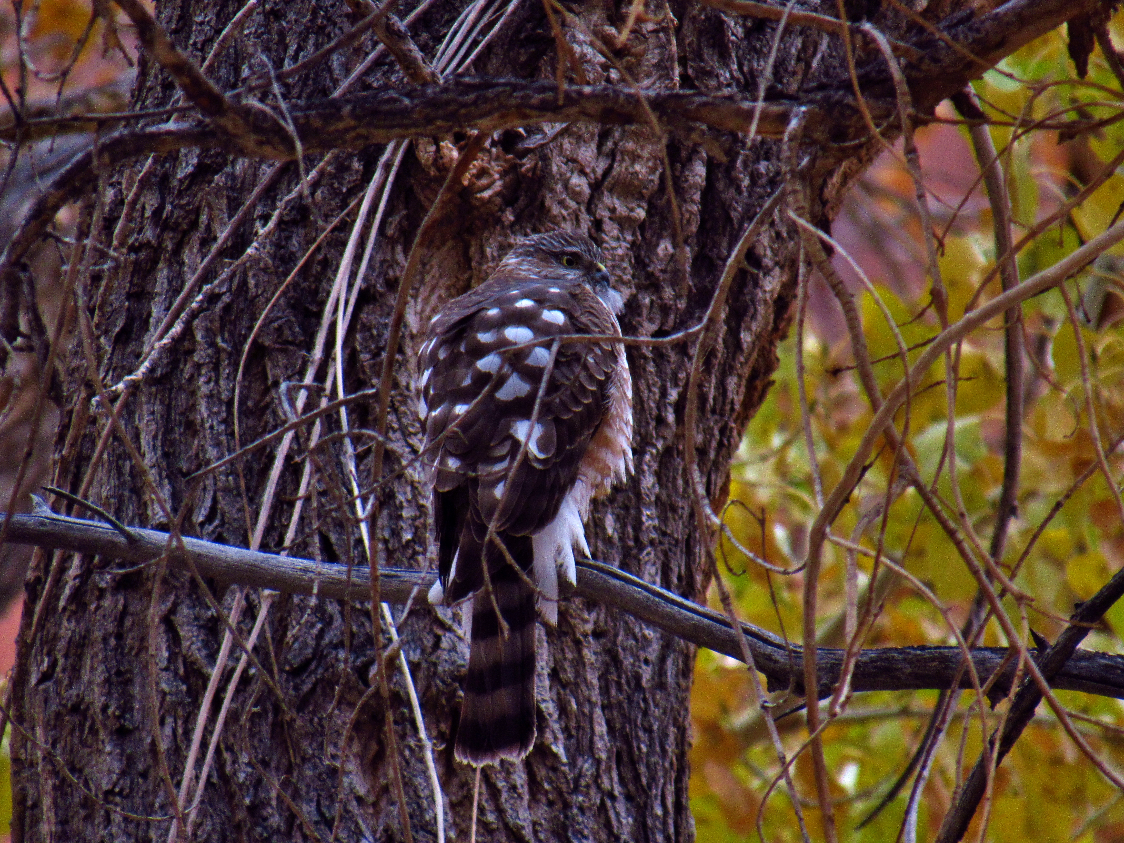
Sharp Shinned Hawk, photographed just before my camera battery crapped out in the cold air
The most challenging section demanded awkward scrambling and butt-scooting for about a mile through big-blocky-bouldery-tumbly stuff. The pack makes me feel wobbly, but I move slowly, methodically, occasionally climbing up high to scout out my line. I focus on opposing forces and friction, especially through moves with oh-shit-button-consequences and wet feet, like when scooting down a 12 foot slabby boulder that sits on the edge of a 6 foot pourover, with exactly 2 little toe holds to catch myself on at the bottom. I had to do pack-on chest-dip moves to get my leg up somewhere, crawl through small holes between 2 rocks and the ground, and tiptoe through the crypto mid-bushwhack, which again, was all made extra difficult with my pack. Crossing the creek might have been as easy as a couple of quick rock hops, but was not limited to giant leaps across the deep canal straight into the bushes, balancing on wobbly driftwood to keep my feet out of the water, downclimbing the tangled roots of the willows and tamarisks and back up them onto the other side, or even a patch of legitimate gravelly quicksand that could’ve sucked me in up to my thigh had it not been for a quick step that kept it at the shin. Among the boulders, shiny grey creek grasses danced hypnotically under the surface, and I found three very inconspicuous mushrooms growing perhaps one inch tall in a particularly wet patch of sand. At one bend, the creek has carved a chute in the bedrock above an almost wash-wide alcove, and a stunning waterfall pours freely into a half frozen pool below, framed by the red Wingate cliffs that today are half-shrouded in clouds. I lunched at the waterfall with an ominous hope that a bobcat was nearby after sighting some fresh scat as wide as my thumb, but I never saw whatever asshole dropped it. Small bubbles burbled up in a stream from the bottom of the pool- gases percolating through the sand or through the skin of some aqueous plant, or some mud buried frogs? Once I was out of the bouldery stuff, it remained bushwhacky and many seeps had hollowed out large sections of the walls along the wash, leaving a surface that looks like skin disease, and I saw some ringtail cat tracks near a spot where salty water trickled straight out of the porous rock. Not much further, a humongous rockfall had blocked off the entire canyon recently, as evidenced by the dust that still sat on the tops of the leaves and the deep gray rubble that surrounded the schoolbus-sized chunks that lay piled on top of one another below a light spot on the wall. I figured it must have happened within the last 2 months, given the heavy rains we had in October that would have washed the dust off the leaves. There were shoeprints and trekking pole holes here too, meaning the hiker must have passed through even more recently, as you could still make out the tread of their shoes in the fine powdery rubble.
Waterfall in Barrier Creek
The blockage had caused the entire creek to back up into a small pond, which had frozen thickly on top in the most shady spots, and in order to get across it, I had to get my feet wet, and so for a large portion of the end of the day, I accepted my fate of cold wet feet and walked through the creek, cold but unobstructed. When I did climb out of the creek, the social/deer trails became more well defined and I could walk at a more comfortable pace through the cottonwood groves. My hunger made itself known and I began looking for a camp with the ideal combination of a safe place for a fire, abundant kindling, flat ground above the potential flash flood area, and where I could have breakfast tomorrow in the first rays of morning sun. I continued searching for 45 minutes with my hunger growing, and when I found the perfect spot, I dutifully filtered/purified my water for tomorrow, gathered wood, got a fire going, and set up camp before starting dinner. I let my shoes and socks dry by the fire while I ate, then stuffed my socks into my inner puffy (I was wearing 2 of them after dark) so that my body heat could continue to dry them through the night, and gazed up at the milky way watching shooting stars go by. This had been the most difficult hiking day so far, and I still managed to knock out 10 miles, which I felt good about, though I began to accept that this loop may take 4 or 5 days more than anticipated at this pace. This trip is not what I am used to in terms of a “thru-hike”, not by a long-shot, but it does feel like the culmination of many skills I have developed over time, and packrafting on the Green River tomorrow will exemplify this the most. I listened to Moby Dick some more toward the end of the day; the part where we learn of Ahab’s initial encounter with the White Whale some years ago. His express duty was to bring the ship, full of oil after a successful season abroad, back to home to Nantucket- to make good on his deals with the ship’s investors, the crew, and his wife and child who all chiefly rely on the him to supply the income from each long trip. But he instead is lured by his own maddened pride to chase the infamous white whale in his thirst for glory, only to have his own whaling boat destroyed right out from under him, his leg bitten off and his mind twisted while swimming after the leviathan with a puny 6″ knife. If it wasn’t the white whale, it would be something else that would torment him, for torment itself is what seems to be his fate, the root of which, as his first mate Starbuck makes clear, is his own selfishness.

Riparian Zone
-

- Biological Soil Crust with Short-Twisted Moss, Southwestern Greenshield, Brown Rock Posy, Olive Earth Lichen, and Desert Brain Lichen

-

- Mormon Tea
-

- Common Reed
-

- Young Yucca
Plan B: Day 5

Biological Soil Crust
Frozen Wash
Rain came in the middle of the night, making me paranoid about the potential for a flash flood and the campsite I had chosen. What if the water came and I wasn’t high enough? I told myself that I had chosen well, but was restless, the highwater marks from way upcanyon were fixed in my mind. Flattened beds of reeds and conspicuous lines high up on the walls 20 miles upcanyon told me that getting flooded out was still possible. Morning came however, and the canyon had not flooded, and I got up early enough to read, write, and make myself an extra cup of coffee. My shoes were fairly dry this morning, which helped a lot with putting them back on, so when I decided to continue walking through the creek, it was because I wanted to and not because I had to. Plus it made for much easier walking than the bushwhacking I had come to expect. Last night’s drizzle meant that the crypto was very green today, but the dampened Wingate cliffs appeared dark and menacing. As I approached the river, the wash widened considerably: both the sand banks and all the plants were taller here given the extra room to grow, and lots of little birds could be seen rooting around in the leaf litter. All in all it was an easy, pleasant day of walking: big overhangs over the creek, a few pretty minuscule wildflowers, and a trek through the abandoned meander of the Green River, the initial into which led me to believe at first that I was much closer to the river than I actually was, since the canyon a mile and a half before I actually get there. Once I got to the river, I set my pack down and searched for a granary I had heard about, but was led astray by misleading cairns and an “X” someone had etched into the wall without anything around it. I followed a shelf around as far as was reasonable, then climbed on top of the hill and walked back to past where I had set my pack down. When I climbed down off the top of the hill, I dropped down a small chute and suddenly found myself in front of some petroglyphs I wasn’t expecting to see: bighorns, alien-like people with horns, and the winding path of a waterway, probably Barrier Creek.

Rock Overhang in Barrier Creek

Petroglyphs by the Green River
I walked back down to my pack and all the way out into the middle of the river corridor on the huge sandbank that extended out of the mouth of Horseshoe Canyon, unpacked my packraft, put my paddle together, and when I went to inflate the thing, I realized that I had forgotten the valve. There was no way to improvise a solution with what I had- my boat could not hold air without that valve. I cursed myself for being so foolish not to triple check that it had been in my packraft repair kit where I normally store it, but I was able to quickly accept that I would not be able to get on the river during this trip, and that I had carried all that extra weight this far for nothing. I had a plan B- the Angel Trail: a steep hike up an old cattle driving trail onto the High Spur, which Mike Kelsey calls in his guidebook, “the steepest cattle trail I’ve ever seen”. I could rejoin with my plan A further down on the High Spur via the Devils Slide Trail. I would be able to see some things I wouldn’t have been able to see from the river, and could shave 2 days off this loop, putting me back on track for the rest of the month. A minor mishap, but nothing is fucked, dude. Bummed, but certainly not dejected, I turned around and retraced my steps all the way back to the base of the Angel Trail where I set up camp for the night. I was still by water, and so I drank my fill; there would likely be no water up on top of the High Spur. After dinner, while writing by the fire, it rained just long enough for me to set up my tarp, then stopped.
Tarp Campfire
Clear and Calm: Day 6

Angel Trail Panorama
A second cup of coffee by the fire in the morning, reading in the sun while my tarp dried out. I figured I could afford to take my time before I left the canyon and the water and the warm fire. I had really enjoyed the spoils of Barrier Creek and I knew I probably wouldn’t enjoy walking through a canyon as fertile as this one for the next couple weeks. Barrier Creek was the exception to the rule: I was still in the desert, about to hike out of the one place with abundant watet. So I waited for the sun, and when it finally crossed the beach around 11:30, I gave it half an hour to dry my stuff out before it the shade came back by 1, when I started the climb out of camp. The ample caves, scat, and tracks on the trail made it apparent that this was mountain lion territory. I’ve never seen a mountain lion, but I had always hoped that if I did that it would be from a point of safety and where we could both act casually. Here, I felt exposed. But I took it slow and steady and enjoyed the view from their front porch every step of the way, reveling in the lush sprawl of Horseshoe Canyon from above. The Angel Trail switchbacked its way among great boulders and across zig-zagging ledges all the way to the top, well cairned, lined, and easy to follow, but definitely steep. Videos taken from my camera could never do it justice. Its slope made it so that one may not necessarily fall very far, but would probably roll and tumble a great distance before coming to a halt. A giant stepped funnel of Wingate led me right to the top, where I could overlook Horseshoe Canyon all the way down to the Green, a sight that I took an extra moment to ensure that I would never forget. It was colder and windier up on top of the spur, but once I found and followed a thin wash that spat me out on the road, the views of the Mineral and Hell Roaring Canyons, the La Sals, the Henrys, the Abajos, the Orange Cliffs and Cleopatra’s Chair, Ekker and Elaterite Buttes, and the Orange Cliffs way out there; literally breathtaking. The road stretched on farther than the eye could see in a thin ribbon across the high mesa.

High Spur Panorama- Click to see full image (large file size)
Once I hit the road, I could zone out and enter a state of moving meditation. I listened to Moby Dick and fell fully into a literary world of fantasy with only the stunning vistas, and the pain in my shoulders and lumber from carrying all that water weight to bring me back. And so the miles slipped away. At some point, looking across the Green River below, I realized I was looking down at Upheaval Dome, unquestionably my favorite place on the planet, so I stopped and took a break simply to let it all sink in. Upheaval Dome is an eroded 60 million year old meteor impact crater, and a symbol of how mother nature is itself a system within a system, and how none of these sets of systems care. We are the only ones who care about the longevity of our ways of life, our traditions, our individualism, and our values. To view the world as something that grows and evolves and expands as a constant is at least small-minded, and at most flat-out false. The world as we know it is just as subject to catastrophic destruction as anything else in a limitless universe. Upheaval Dome is the place I go to remind myself of this. That despite the destructive chaos of the universe, we emerged with an the empathy to care about it and our world and each other is the most beautiful thing imaginable to me, and it brings me peace. This is my god, and Upheaval Dome is my temple. I followed the long road until dark, set up a cowboy camp on a ridge where I could catch first sun, even though it was very cold, and had dinner while curled up in my sleeping bags. I watched the headlights from vehicles way way out there by the San Rafael Swell coming up over a hill, and then I couldn’t see them. Low, swooshy dark clouds began to obscure them, and I went to bed knowing what would be in store tomorrow, hoping at least to catch a good nights sleep before tomorrow came.
Me at Upheaval Dome
Catastrophic Destruction: Day 7
I woke up at about 6AM in total darkness. The sound of snowflakes woke me up, and as I sat up, an inch thick blanket of snow crumbled off my outer sleeping quilt. It was coming down in fat chunks, piling up fast. Out loud, I said, “Oh no”, either to myself or to the storm, hoping it could hear my panic and show pity. I skipped breakfast, packed up all of my stuff quickly, my hands already freezing from brushing off snow from every surface of my cowboy camp, and got onto the road just as I no longer needed to use my headlamp. I turned my back to the wind to look at my phone in cupped hands inside my jacket, trying to figure out how many miles I was from the Land Rover, which was the only reliable shelter I knew to take in a storm like this. 24.3 miles. If I want to make it back to the car and get out of here, I would need to pull off almost a marathon day in the middle of a blizzard. And I very much did want to get out of there. I sure as shit was not going to hike down into Millard Canyon anymore- even with traction aids, it would be sketchy and exceedingly risky, nevermind what I would do once I got down there. There was no question, I had to get back to the car first. I had no idea how much it would snow or what the weather would be like tomorrow, be it more unseasonably heavy snow or an unseasonably blisteringly hot sun, but the conservative decision here was to get to the car and reassess my strategy from there. I was really hoping I wouldn’t have to make it that far by tonight, but I couldn’t be sure that I could find any other suitable shelter out here with the way it was snowing. Visibility was very low, so even if there was a cave right next to the road I might not be able to see it, and my tarp was barely sufficient for these conditions even if I found a good spot to set it up. I started walking and told myself I would not stop. My ace in the hole since the PCT was that I can always hike out. All I would have to do is get to the land rover, and I could probably drive out of here, have a cup of hot chocolate at the gas station in Green River in the middle of the night, and sleep in my bed net to the wood stove tonight. To the car, drive out of here, hot chocolate, bed, fire. I repeated this to myself as a mantra to keep my feet moving. My shoes froze on my feet while I trudged through the deepening snow. 3 inches, 6 inches, 10 inches, up to my shins and I still kept trudging along, repeating my mantra. I did not set my pack down for more than about 2 minutes, and only did so twice to get frozen granola bars out of my pack when I got really hungry; it was too cold for me to stop and I would feel it in my extremities very quickly. The hose for my water bladder froze, and after a couple hours, so did the remaining little water I had in my nalgenes that I had slept with that night, and so while it gradually thawed inside my jacket pockets over the next couple hours, I was thirsty. The wind blew from the southwest, covering my right side with a thick layer of snow and ice, freezing my mustache, and fogging my sunglasses whenever I pulled my buff over my nose so that I had to choose between a warm face or not getting snow in my eyes. To the car, drive out of here, hot chocolate, bed, fire. I saw one small bird fly into a dense juniper, the only animal I would see all day, though I did see a couple of rabbit tracks few and far between. My feet would lose traction on the underlying slickrock, causing me to splay out and try to catch myself with my trekking poles every few hundred yards, and during the heaviest part of the storm, I could only tell that I was still on the road because of the small drainages along the side of the road left by the graders that maintain. Stepping thigh deep into the snow was the sign that I had reached the edge of the road. I did leave the road very briefly to check out what I thought might be a good cave to hide out in, but it was just as snowed in as everything else. Every sizeable tree seemed like a good place to set up a hammock camp where I could get out of the snow, but the pinyons and junipers don’t lend themselves to good hammock camps generally, and a hammock camp would have been the only reasonable setup with my gear and how much the snowpack had already accumulated under the low branches. At each tree I struggled to arrive at the decision to keep moving. Every few hours, I would pass a notable waypoint, like the first sign that pointed to Horseshoe Canyon at mile 8.5, the second one at mile 10, and eons later, Hans Flat at mile 22, and I refused to check the GPS on my phone to quickly see how many miles I had come and how many I had to go. It did not matter, I just had to keep moving and eventually I would get there. To the car, drive out of here, hot chocolate, bed, fire. The sun came out for the last hour of the day, and the landscape opened up to reveal the epic beauty of the desert snowscape. The Henrys were socked in, the red rock was carpeted with the dampening quiet of thick snow, the wide open flats a featureless white landscape; a more inhospitable and unforgiving landscape I have never witnessed. I got to take my outer puffy off comfortably for about half an hour towards the end of the day, and I listened to an episode of the Trail Show about Dirtmonger being so dehydrated that he pissed blood on the Desert Trail, and felt better about how I was doing, because although it had been a long day, I was far from full on survival mode. As I approached Hans Flat, I wondered if I would see anyone. The sun went down and it got cold again, so back on with the puffy. When I got to the rangers station, there were no footprints, and no one had driven on the road here yet either. As far as I knew, I was the only one out here right now. There were no lights on in the ranger housing, and even if there were, how would that change anything for me at this point? I was cold and tired, but I had made it this far. Very much type 2, but I was now only 2 miles and some change away from the car. It was my my 4th or 5th wind moving me forward, and having been through the waves of hunger and thirst, alternately numb and needly fingers and toes, and soreness in my back, shoulders, and feet, the struggles had become entirely mental at that point. And I’ve got more than Malcolm Gladwell’s 10,000 hours with exercising that kind of willpower. Those last 2 miles under the stars were the longest. Every change in the topography on the left side of the road looked like the turn off to the Land Rover, but never was. I checked my mileage more times within the last two miles than I had all day, and especially within the last half mile. I could see the headlights on the cars way out by the Swell again. When I made it to the turn off, I felt a pre-triumphant sense of accomplishment. I can always hike out, confirmed again this time, but not easily at all. The stars were incredible up here, and shooting stars streamed across the sky just as often as the satellites made their slow traverses. Cows had walked on the road here since it snowed, affording me a brief respite in the last few tenths of a mile. I walked the last few steps to the car with tired purpose now. I opened the trunk of the Land Rover thoughtfully (it ain’t my rig), threw my backpack in there, put my phone and wallet in my pockets because those would be important again soon, and reconnected the battery. When I opened the drivers door the car alarm went off, scaring me for a moment in my zombie stupor, and then making me laugh at the banality of it. I put the key in the ignition, the dashboard lights came on and I anxiously awaited the heat on my toes and the flick of headlights. Turned the key… Nothing. Nothing at all. The dash lights are still on, no battery or check engine light or even low tire pressure, but no starter noises or any response from the motor. I tried again. Nothing. And again, now just vainly hoping it was a fluke. Nothing. Hot chocolate. Bed. Fire. That’s all that was left. How could this happen? I whacked the starter and tried again. Nothing. I looked up and put woven fingers on top of my head, feeling totally lost and incapable. A deep, gathered sigh. I won’t make it out tonight, but I can figure it out in the morning. It’s been a long day, and what I probably need more than anything is to eat some food, drink lots of water, and get to sleep. I have enough gear to stay warm, and most importantly, I made it to reliable shelter in case it snows again. I ate cold trail mix for dinner, curled up in the fetal position, cramped in the backseat, drank some frigid sips of water, and was out like a light. It was a cold night, the kind where my cold toes continued to wake me up throughout the night, and I greatly looked forward to the return of the sun.

Snowy Twin Corral Box Canyon, 2 days after
It had been nearly 6 years since I had been stuck in a winter storm like this, and I had vowed to myself then that I never wanted to go through that experience again; that I had enough experience to be prepared for whatever I might face so that I was never stuck, through planning, physical preparation, reliable and appropriate gear, and finely honed skills; that I was privileged enough to decide when I would have to face winter again, like when to step into the creek with dry shoes. And here I was, stuffed into the backseat of a car that won’t start in the middle of nowhere, in a landscape swallowed by a winter storm. Long story short, I pressed the button. Thankfully, not the oh-shit-button, but the vehicle rescue button. Again. And a coworker of mine came to pick me up the following day, and I went back the following day to pick up the Land Rover. I felt so eternally grateful for Larry when he came to pick me up, as I had no way of knowing that he’d be able to get to me in the snow, and I had starting constructing exit strategies in case he couldn’t. I walked through Moab on one of the following days, bundled up with an unnecessary amount of layers for such a short walk, looking up at the Portal, where the Colorado River reenters the canyon downstream from town, thinking about how it all went wrong. I had crashed my motorcycle. I forgot the valve for my packraft and had to bail on my original plan. I had to use the ace in the hole and hike out to keep myself safe. And I had to spend 5 days doing vehicle rescues for what ended up being just a week of walking, not the month that I had planned. But ultimately all of these things were within my control. I could have accounted for all of those variables and created solutions for each one had I thought a little more or had some more experience. The part that really went wrong was entirely out of my control: the largest early-season snowstorm in nearly 30 years. As I regaled my roommates with the whole tale, one of them put it best. “It’s not just that Mother Nature doesn’t care out there, man. Out there, it maybe even doesn’t like you a little bit”. This is my white whale, the Maze, or more generally Canyonlands NP, be it this misadventure, or the one I had trekking in the Needles two and a half years ago, or the ones I’ve had in Cataract Canyon during the boating season, it is the place that has challenged me the most. The one that earned that same kind of respect from the native people, the early explorers, the cowboys and miners, and the first couple generations of recreationalists long before I got here, and when it took something from me, I swore that I would take it back. Like Ahab, it is my pride that I wish to retrieve, and hell alone will stop me from getting it. It is a curse that I am well aware of, and yet one I cannot seem to remedy. I am driven to explore, and in particularly isolated places, and especially by myself. It is where I feel most alive. It is what makes me proud of myself, and at one with the world. There is much to be grateful for back on land: the wife, the heart, the bed, the table, the saddle, the fire-side, the country. But getting out there into the last little patches of wild spaces left does not feel like a choice, but an external force that dictates my values and decisions. My life is the river, existing inside and outside of myself, fleetingly and eternally, impossibly huge and infinitesimally small in complex holes, eddies, and long sections of flatwater. It is composed of the fulfillment of my needs, and completed with the fulfillment of my wants, and is balanced by equal shares of selfishness and selflessness. And not matter how much I may care about the past, present, and future of my life, the world does not. While the river will simply, naturally follow the path of least resistance, I may not. For the chance to examine life itself and my place within it, I am grateful. I shall return.
La Sal Mountains Overlook from the High Spur